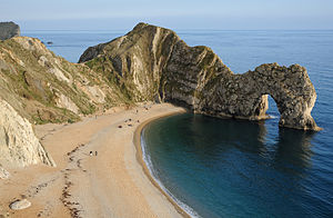
Durdle Door
This article includes a list of general references, but it lacks sufficient corresponding inline citations. (August 2011) |

Durdle Door is a natural limestone arch on the Jurassic Coast near Lulworth in Dorset, England.[1] It is privately owned by the Welds, a family who own 12,000 acres (50 km2) in Dorset in the name of the Lulworth Estate.[2] It is open to the public. The name Durdle is derived from the Old English 'thirl' meaning bore or drill.
Geology

The arch has formed on a concordant coastline where bands of rock run parallel to the shoreline.[citation needed] The rock strata are almost vertical, and the bands of rock are quite narrow. Originally a band of resistant Portland limestone ran along the shore, the same band appears one mile along the coast forming the narrow entrance to Lulworth Cove. Behind this is a 120-metre (390 ft) band of weaker, easily eroded rocks, and behind this is a stronger and much thicker band of chalk, which forms the Purbeck Hills.
The limestone and chalk are in closer proximity at Durdle Door than at Swanage, 10 miles (16 km) to the east, where the distance is over 2 miles (3 km).[citation needed] There are at least three reasons for this. Firstly, the beds are highly inclined (whilst more gently inclined at Swanage). Secondly, some of the beds have been cut out by faulting; and thirdly, the area around Durdle Door seems unusually shallow, so thinner bands of sediments were deposited. At Durdle Bay nearly all of the limestone has been removed by sea erosion, whilst the remainder forms a small headland. Erosion at the western end of the limestone band has resulted in the arch formation. UNESCO teams have been working on saving both the arch and adjacent beach.[citation needed]
The 120-metre (390 ft) isthmus which joins the limestone to the chalk is made of a 50-metre (160 ft) band of Portland limestone, which is less resistant than the Purbeck beds, a narrow and compressed band of Cretaceous clays — Wealden Clay, sands and chert beds — and then narrow bands of Greensand and sandstone.[citation needed] In Man of War Bay, the small bay immediately east of Durdle Door the Portland stone has not been entirely eroded away, and at low tide the band of Portland stone is partially revealed.
In literature and popular culture
Music videos have been filmed at Durdle Door, including parts of Tears for Fears' Shout, Cliff Richard's 1990 Christmas number one Saviour's Day, Billy Ocean's Loverboy and Bruce Dickinson's Tears of the Dragon.[citation needed]
The third story in Ron Dawson's Amazing Adventures of Scary Bones the Skeleton series creates a magical myth of how Durdle Door came to be.[citation needed] In Scary Bones meets the Dinosaurs of the Jurassic Coast, the story's heroes meet an as yet undiscovered dinosaur called Durdle Doorus. At the end of the story Durdle Doorus is transformed into Durdle Door with the validity of the transformation demonstrated by an illustration and photograph.
The artwork inside the lyric booklet for Pink Floyd's The Division Bell includes a scene photographed at Durdle Door.[citation needed]
In Nanny McPhee, the children go for a picnic on the beach at Durdle Door.[citation needed]
Scenes from the film Wilde (1997) starring Stephen Fry were shot here.[citation needed]
Scenes from the film Far From The Madding Crowd (1967) were shot here, including at Scratchy Bottom.[3]
The Bull
The Bull (50°37′16″N 2°16′48″W / 50.6210°N 2.2801°W) is a rock that lies out to sea close to Durdle Door. It is a continuation of the rock strata that form Durdle Door itself.
See also
- Swyre Head and Bat's Head, to the west
- Stair Hole
- List of Dorset beaches
- List of places on the Jurassic Coast
- Delicate Arch and Landscape Arch in the USA
- Durdle Pier, Isle of Portland
References
- ^ West, I.W., 2003. "Durdle Door; Geology of the Dorset Coast". Southampton University, UK. Version H.07.09.03.
- ^ "The Purbeck Gazette". Retrieved 6 April 2012.
- ^ "Far from the Madding Crowd (1967) — Filming locations". Retrieved 2008-10-25.
Further reading
- Arkell, W.J., 1978. The Geology of the Country around Weymouth, Swanage, Corfe and Lulworth, 4th pr.. London: Geological Survey of Great Britain, HMSO.
- Davies, G.M., 1956. A Geological Guide to the Dorset Coast, 2nd ed.. London: Adam & Charles Black.
- Dawson,R, 2010. Scary Bones the Skeleton meets the Dinosaurs of the Jurassic Coast . Mulberry Tree Books.
- Perkins, J.W., 1977. Geology Explained in Dorset. London: David & Charles.
External links
Photos tagged with "Durdledoor" at Flickr
