Dyavolska reka
Appearance
| Dyavolska reka | |
|---|---|
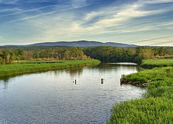
 The mouth of the Devil's River | |
| Location | |
| Country | Bulgaria |
| Physical characteristics | |
| Mouth | |
• location | Black Sea |
• coordinates | 42°15′54″N 27°45′16″E / 42.2650°N 27.7545°E |
The Dyavolska reka (Bulgarian: Дяволска река, "devil's river") is a river in Burgas Province, southeastern Bulgaria. It originates in the Strandzha mountains, runs near the coastal town of Primorsko, and flows into the Black Sea. In its middle course, it forms a marshy area known as Dyavolsko blato (Bulgarian: Дяволско блато, "devil's swamp").
