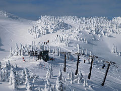
Eaglecrest Ski Area
| Eaglecrest Ski Area | |
|---|---|
 Top of the recently opened Black Bear Chair | |
| Location | Douglas Island,, Alaska |
| Nearest major city | Juneau |
| Coordinates | 58°16′34″N 134°30′55″W / 58.27611°N 134.51528°W |
| Vertical | 1620 ft |
| Top elevation | 2750 |
| Base elevation | 1130 |
| Skiable area | 640 acres (2.6 km2) |
| Trails | 34 |
| Longest run | 2 mi |
| Lift system | 4 chairs |
| Snowfall | 350 in |
| Snowmaking | Yes |
| Website | Eaglecrest Ski Area |
Eaglecrest Ski Area is a public ski area on Douglas Island in the U.S. state of Alaska, across Gastineau Channel from Juneau. Eaglecrest has 4 double chairlifts accessing 640 acres (2.6 km2), with 34 marked alpine runs, 2 Nordic skiing loops and access to world class backcountry. Vertical drop is 1,400 ft (430 m) with an average snowfall of 200-500".[1] The area is owned and operated by Juneau's municipal government, though some legislators of the region, including Randy Wanamaker, have suggested privatization.
Southeast Alaska's only ski area, Eaglecrest's season generally runs from the first weekend of December to the end of April. After two season of relatively small snowfall, Eaglecrest is making vast improvements on snow making mechanisms, grooming and trimming trails and general operation to ensure timely openings, even with limited snowfall.
Eaglecrest is family and community oriented, with many community outreach and programs available for skiers and riders of all ages. Their award winning Snowsport School and certified instructors work to teach students of all ages the skills they need to be independent and safe skiers and riders.
References
- ^ "Archived copy". Archived from the original on 2011-05-01. Retrieved 2011-02-14.
{{cite web}}: Unknown parameter|dead-url=ignored (|url-status=suggested) (help)CS1 maint: archived copy as title (link)
External links
 Media related to Eaglecrest Ski Area at Wikimedia Commons
- SkiJuneau.com - official site
58°16′34″N 134°30′55″W / 58.27611°N 134.51528°W
