
Ebermannsdorf
Ebermannsdorf | |
|---|---|
 Ebermannsdorf Castle | |
 Coat of arms | |
Location of Ebermannsdorf within Amberg-Sulzbach district 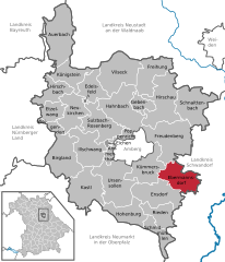 | |
 Ebermannsdorf  Ebermannsdorf | |
| Coordinates: 49°23′35″N 11°56′15″E / 49.39306°N 11.93750°E | |
| Country | Germany |
| State | Bavaria |
| Admin. region | Oberpfalz |
| District | Amberg-Sulzbach |
| Government | |
| • Mayor | Josef Gilch (CSU) |
| Area | |
| • Total | 45.39 km2 (17.53 sq mi) |
| Elevation | 396 m (1,299 ft) |
| Population (2022-12-31)[1] | |
| • Total | 2,397 |
| • Density | 53/km2 (140/sq mi) |
| Time zone | UTC+01:00 (CET) |
| • Summer (DST) | UTC+02:00 (CEST) |
| Postal codes | 92263 |
| Dialling codes | 09624 |
| Vehicle registration | AS |
| Website | www.Ebermannsdorf.de |
Ebermannsdorf is a municipality in the district of Amberg-Sulzbach in Bavaria in Germany.
History
Eppo von Ebermannsdorf was first mentioned in 1079.
References
- ^ Genesis Online-Datenbank des Bayerischen Landesamtes für Statistik Tabelle 12411-003r Fortschreibung des Bevölkerungsstandes: Gemeinden, Stichtag (Einwohnerzahlen auf Grundlage des Zensus 2011) (Hilfe dazu).
Towns and municipalities in Amberg-Sulzbach | ||
|---|---|---|
|  | |
| International | |
|---|---|
| National | |
This Amberg-Sulzbach location article is a stub. You can help Wikipedia by expanding it. |