
Elleben
Elleben | |
|---|---|
Location of Elleben within Ilm-Kreis district 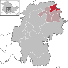 | |
| Country | Germany |
| State | Thuringia |
| District | Ilm-Kreis |
| Municipal assoc. | Riechheimer Berg |
| Subdivisions | 3 |
| Government | |
| • Mayor | Rudolf Neubig |
| Area | |
| • Total | 17.01 km2 (6.57 sq mi) |
| Elevation | 320 m (1,050 ft) |
| Population (2022-12-31)[1] | |
| • Total | 888 |
| • Density | 52/km2 (140/sq mi) |
| Time zone | UTC+01:00 (CET) |
| • Summer (DST) | UTC+02:00 (CEST) |
| Postal codes | 99334 |
| Dialling codes | 036200 |
| Vehicle registration | IK |
| Website | www.vg-riechheimer-berg.de |
Elleben is a municipality in the district Ilm-Kreis, in Thuringia, Germany. Elleben has two named communities, Riechheim and Gügleben.
History
Within the German Empire (1871-1918), Elleben was part of the Principality of Schwarzburg-Sondershausen, while Riechheim and Gügleben were part of the Duchy of Saxe-Meiningen.
Towns and municipalities in Ilm-Kreis | ||
|---|---|---|
 | ||
References
| International | |
|---|---|
| National | |
This Ilm-Kreis location article is a stub. You can help Wikipedia by expanding it. |