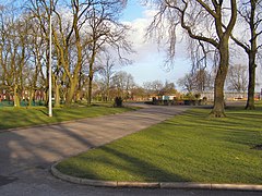
Elton, Greater Manchester
Appearance
| Elton | |
|---|---|
 Whitehead Park, Elton | |
Location within Greater Manchester | |
| Population | 11,464 (2011) |
| OS grid reference | SD791106 |
| Metropolitan borough | |
| Metropolitan county | |
| Region | |
| Country | England |
| Sovereign state | United Kingdom |
| Post town | BURY |
| Postcode district | BL8 |
| Dialling code | 0161 |
| Police | Greater Manchester |
| Fire | Greater Manchester |
| Ambulance | North West |
| UK Parliament | |
Elton is a suburb of Bury, in the county of Greater Manchester, England. The population of the ward at the 2011 census was 11,464.[1] The River Irwell flows through the area via Burrs Country Park, formerly cotton mills,[2] some features of which are still visible.
Elton is a halt on the East Lancashire Railway heritage line.
History
[edit]Elton was formerly a township in the parish of Bury and a chapelry,[3] in 1866 Elton became a separate civil parish,[4] on 30 September 1902 the parish was abolished and merged with Ramsbottom, Bury, Ainsworth and Radcliffe, part also went to form Tottington.[5] In 1891 the parish had a population of 12,589.[6]
References
[edit]Wikimedia Commons has media related to Elton, Greater Manchester.
- ^ "Bury Ward population 2011". Retrieved 3 January 2015.
- ^ Fairbairn, William (2014), "COTTON MILLS", Treatise on Mills and Millwork, Cambridge University Press, pp. 469–479, doi:10.1017/cbo9781107256682.022, ISBN 9781107256682
- ^ "History of Elton, in Bury and Lancashire". A Vision of Britain through Time. Retrieved 5 November 2024.
- ^ "Relationships and changes Elton CP/Tn through time". A Vision of Britain through Time. Retrieved 5 November 2024.
- ^ "Bury Registration District". UKBMD. Retrieved 5 November 2024.
- ^ "Population statistics Elton CP/Tn through time". A Vision of Britain through Time. Retrieved 5 November 2024.

