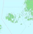
File:Åland map with borders.svg
Appearance

Size of this PNG preview of this SVG file: 543 × 600 pixels. Other resolutions: 217 × 240 pixels | 435 × 480 pixels | 695 × 768 pixels | 927 × 1,024 pixels | 1,854 × 2,048 pixels | 996 × 1,100 pixels.
Original file (SVG file, nominally 996 × 1,100 pixels, file size: 67 KB)
File history
Click on a date/time to view the file as it appeared at that time.
| Date/Time | Thumbnail | Dimensions | User | Comment | |
|---|---|---|---|---|---|
| current | 11:04, 30 May 2024 |  | 996 × 1,100 (67 KB) | GrandEscogriffe | tweak of Sweden-Finland border south of Åland |
| 10:53, 30 May 2024 |  | 996 × 1,100 (67 KB) | GrandEscogriffe | extension to the South | |
| 16:24, 19 April 2006 |  | 996 × 1,004 (65 KB) | Para | thicker lines for visibility in thumbs | |
| 22:10, 18 April 2006 |  | 996 × 1,004 (65 KB) | Para | {{Information| |Description=Map of Åland with borders as mentioned in the ''"Convention on the non-fortification and neutralization of the Åland islands"'', ratified 1922 ([http://www.finlex.fi/fi/sopimukset/sopsteksti/1922/19220001 Finnish]/[http://www |
File usage
The following page uses this file:
Global file usage
The following other wikis use this file:
- Usage on ar.wikipedia.org
- Usage on bg.wikipedia.org
- Usage on bn.wikipedia.org
- Usage on ca.wikipedia.org
- Usage on el.wikipedia.org
- Usage on es.wikipedia.org
- Usage on et.wikipedia.org
- Usage on fa.wikipedia.org
- Usage on fr.wikipedia.org
- Usage on hr.wikipedia.org
- Usage on kk.wikipedia.org
- Usage on ky.wikipedia.org
- Usage on lt.wikipedia.org
- Usage on no.wikipedia.org
- Usage on ru.wikipedia.org
- Usage on sh.wikipedia.org
- Usage on sr.wikipedia.org
- Usage on tr.wikipedia.org
- Usage on uz.wikipedia.org
- Usage on xmf.wikipedia.org

