
File:1913 Balloon Borne Pyrheliometer.jpg

Size of this preview: 800 × 581 pixels. Other resolutions: 320 × 232 pixels | 640 × 465 pixels | 1,024 × 743 pixels | 1,280 × 929 pixels | 2,560 × 1,858 pixels | 5,026 × 3,648 pixels.
Original file (5,026 × 3,648 pixels, file size: 17.45 MB, MIME type: image/jpeg)
| This is a file from the Wikimedia Commons. Information from its description page there is shown below. Commons is a freely licensed media file repository. You can help. |
Summary
| Description |
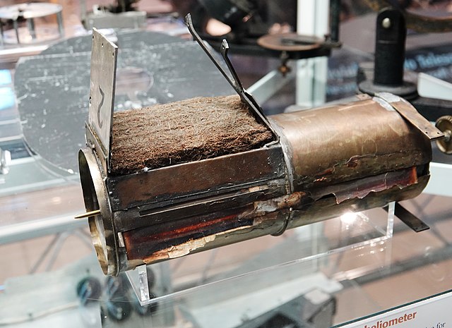
English: These are parts from balloon-borne pyrheliometer #2 designed by Charles Greeley Abbot and built by his craftsman Andrew Kramer at the original Smithsonian Astrophysical Observatory in about 1913. Following designs that had been developed for meteorographs, the recording medium was sensitized photographic paper on a slowly rotating drum. The drum was encased in a light-tight chamber save for an entrance slit parallel to the diameter. A thermometer filled the slight so that the mercury level would be recorded by the rotating paper as a function of time, and of altitude, as recorder by a barometric needle whose shadow was also superimposed. Other clockdriven elements periodically exposed the bulb of the thermometer to direct skylight and to ambient air temperature. This instrument stands as a milestone in sophistication and ingenuity in early self-registering automata. The balloon-sondes were lofted from Catalina Island off the coast of California and some reached 25 kilometers altitude. Data from these devices led to greatly refined values of Langley's solar constant, and helped to establish the modern range. A complete unit (#3) is preserved at the National Museum of American History. These parts were retrieved from the stores of the original SAO workshops, housed in the Garber facility, in the mid-1980s. Picture taken at the National Air and Space Museum's Steven F. Udvar-Hazy Center in Chantilly, Virginia, USA. |
| Date | |
| Source | Own work |
| Author | Sanjay Acharya |
| Camera location | | View this and other nearby images on: OpenStreetMap |
|---|
Licensing
I, the copyright holder of this work, hereby publish it under the following license:
This file is licensed under the Creative Commons Attribution-Share Alike 4.0 International license.
- You are free:
- to share – to copy, distribute and transmit the work
- to remix – to adapt the work
- Under the following conditions:
- attribution – You must give appropriate credit, provide a link to the license, and indicate if changes were made. You may do so in any reasonable manner, but not in any way that suggests the licensor endorses you or your use.
- share alike – If you remix, transform, or build upon the material, you must distribute your contributions under the same or compatible license as the original.
File history
Click on a date/time to view the file as it appeared at that time.
| Date/Time | Thumbnail | Dimensions | User | Comment | |
|---|---|---|---|---|---|
| current | 21:34, 16 December 2018 | | 5,026 × 3,648 (17.45 MB) | Sanjay ach | User created page with UploadWizard |
File usage
The following pages on the English Wikipedia use this file (pages on other projects are not listed):
Global file usage
The following other wikis use this file:
- Usage on fa.wikipedia.org