
File:2007-03-25 Japan Noto earthquake.png
No higher resolution available.
2007-03-25_Japan_Noto_earthquake.png (456 × 499 pixels, file size: 29 KB, MIME type: image/png)
| This is a file from the Wikimedia Commons. Information from its description page there is shown below. Commons is a freely licensed media file repository. You can help. |
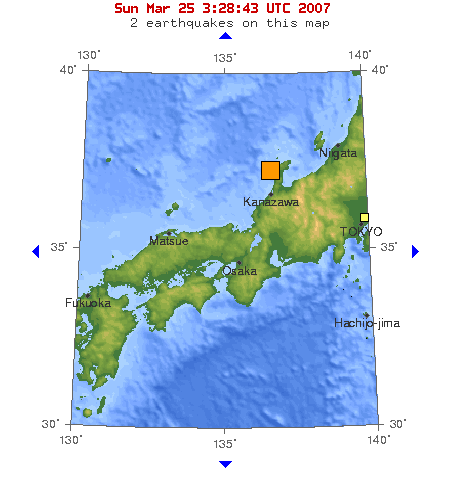
Map of Magnitude 6.7 earthquake in near the west coast of honshu(Noto Peninsula),Japan, 2007-03-25.
Source : [1]
This image is in the public domain in the United States because it only contains materials that originally came from the United States Geological Survey, an agency of the United States Department of the Interior. For more information, see the official USGS copyright policy.
|
Original upload log
| Date/Time | Dimensions | User | Comment |
|---|---|---|---|
| 25 March 2007, 05:53:01 | 456 × 499 (33284 bytes) | Pekachu (talk · contribs) | Map of Magnitude 6.7 earthquake in near the west coast of honshu([[w:Noto Peninsula|]]),Japan, 2007-03-25. Source : [https://earthquake.usgs.gov/eqcenter/recenteqsww/Maps/10/135_35.php] {{PD-USGov-USGS}} |
File history
Click on a date/time to view the file as it appeared at that time.
| Date/Time | Thumbnail | Dimensions | User | Comment | |
|---|---|---|---|---|---|
| current | 09:40, 21 July 2014 | | 456 × 499 (29 KB) | GifTagger | Bot: Converting file to superior PNG file. (Source: 2007-03-25_Japan_Noto_earthquake.gif). This GIF was problematic due to non-greyscale color table. |
File usage
No pages on the English Wikipedia use this file (pages on other projects are not listed).
Global file usage
The following other wikis use this file:
- Usage on ja.wikipedia.org
- Usage on ja.wikinews.org
- Usage on th.wikipedia.org