
File:2013-05-26–31 tornado outbreak 2013-05-31 2310Z (unannotated).png

Size of this preview: 800 × 450 pixels. Other resolutions: 320 × 180 pixels | 640 × 360 pixels | 1,024 × 576 pixels | 1,280 × 720 pixels | 2,048 × 1,152 pixels.
Original file (2,048 × 1,152 pixels, file size: 4.12 MB, MIME type: image/png)
| This is a file from the Wikimedia Commons. Information from its description page there is shown below. Commons is a freely licensed media file repository. You can help. |
.png)
| Description |
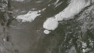
English: This image from GOES East, taken at 2310Z on May 31, 2013, five minutes after the NOAA National Weather Service Storm Prediction Center received a report of a tornado on the ground, shows the massive system that spawned a long track tornado, assigned a rating of EF-5 on June 4, 2013, that caused extensive damage in areas around El Reno and Union City, Oklahoma. Three seasoned tornado researchers were among the deaths attributed to an extended tornado outbreak from May 26 through May 31, 2013. Credit: NOAA Environmental Visualization Laboratory |
|||
| Date | ||||
| Source | http://www.nnvl.noaa.gov/MediaDetail2.php?MediaID=1361&MediaTypeID=1 | |||
| Author | Derivative of File:20130531-ElRenoOK 2310Z.png, annotations removed by Dustin V. S. using Paint.NET | |||
| Permission (Reusing this file) |
|
|||
| Other versions | File:20130531-ElRenoOK 2310Z.png (annotated version) |
File history
Click on a date/time to view the file as it appeared at that time.
| Date/Time | Thumbnail | Dimensions | User | Comment | |
|---|---|---|---|---|---|
| current | 01:38, 19 September 2014 | | 2,048 × 1,152 (4.12 MB) | Master of Time | {{Information |Description ={{en|1=This image from GOES East, taken at 2310Z on May 31, 2013, five minutes after the NOAA National Weather Service Storm Prediction Center received a report of a tornado on the ground, shows the massive system th... |
File usage
The following pages on the English Wikipedia use this file (pages on other projects are not listed):
.png)