
File:A company of 'Kanwar Yatra' devotee raising the slogan to hail the mighty Shiva.jpg

Size of this preview: 800 × 533 pixels. Other resolutions: 320 × 213 pixels | 640 × 427 pixels | 1,024 × 683 pixels | 1,280 × 853 pixels | 2,560 × 1,707 pixels | 6,000 × 4,000 pixels.
Original file (6,000 × 4,000 pixels, file size: 14.1 MB, MIME type: image/jpeg)
| This is a file from the Wikimedia Commons. Information from its description page there is shown below. Commons is a freely licensed media file repository. You can help. |
Summary
| Description |
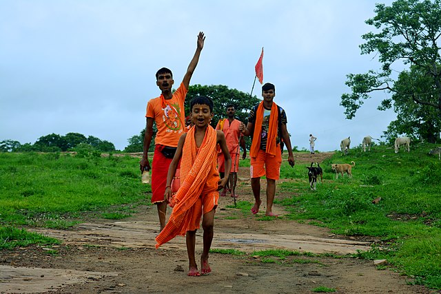
English: Kanwar Yatra or Kawad Yatra (कांवड़ यात्रा) is an auspicious pilgrimage observed by the devotees of Lord Shiva annually. This yatra is also called Jal Yatra as in this practice the bearer known as ‘Kanwariyas’ (कांवड़ियों) or Kanvadias go the Hindu pilgrimage places in the state of Bihar, Uttar Pradesh, Gangotri, and Gaumukh in Uttarakhand and Haridwar to fetch water from the Holy Ganges and then offer the ‘Ganga Jal’ to Shiva temples in their hometowns.
Kanwar Yatra takes place during the Hindu month of Shravan that corresponds to the month of July to August in the English calendar. It starts on Pradipada tithi (the first day) of Shravan month as per the Hindu calendar. During the Kanvar Yatra, the devotees carry the ‘Kanvar’ on both their shoulders. ‘Kanvar’ is a small pole made from bamboo to which two colored earthen pots are tied on the opposite ends. During this pilgrimage journey, the Kanvarias fill the earthen pots with holy water for offering in Lord Shiva’s temple by balancing the Kanvars on their shoulders. The Kanwar Yatra is a month long ritual in which the Kanvarias wear saffron-colored clothes and walk barefooted to collect the holy water from the chosen pilgrimage destinations. The devotees then return to their hometown and perform the ‘abhishekam’ (holy anointment) of the Shivling at the local temple. It is considered to be an act of thanksgiving for all the fortunate things in their life. The only thing to take care is that the earthen pots should not touch the ground at any point of the journey. There are numerous makeshift stands constructed across the journey, using which the Kanvarias can take some rest for a while.
|
||
| Date | |||
| Source | Own work | ||
| Author | Snipershanu |
| Camera location | | View this and other nearby images on: OpenStreetMap |
|---|
Licensing
I, the copyright holder of this work, hereby publish it under the following license:
This file is licensed under the Creative Commons Attribution-Share Alike 4.0 International license.
- You are free:
- to share – to copy, distribute and transmit the work
- to remix – to adapt the work
- Under the following conditions:
- attribution – You must give appropriate credit, provide a link to the license, and indicate if changes were made. You may do so in any reasonable manner, but not in any way that suggests the licensor endorses you or your use.
- share alike – If you remix, transform, or build upon the material, you must distribute your contributions under the same or compatible license as the original.
This image was uploaded as part of Wiki Loves Folklore photographic contest.
|
File history
Click on a date/time to view the file as it appeared at that time.
| Date/Time | Thumbnail | Dimensions | User | Comment | |
|---|---|---|---|---|---|
| current | 13:19, 4 February 2020 | | 6,000 × 4,000 (14.1 MB) | Snipershanu | User created page with UploadWizard |
File usage
No pages on the English Wikipedia use this file (pages on other projects are not listed).