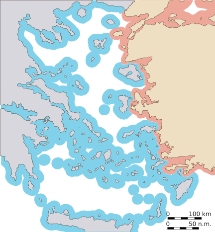
File:Aegean 10 nm.svg
Appearance

Size of this PNG preview of this SVG file: 432 × 467 pixels. Other resolutions: 222 × 240 pixels | 444 × 480 pixels | 710 × 768 pixels | 947 × 1,024 pixels | 1,894 × 2,048 pixels.
Original file (SVG file, nominally 432 × 467 pixels, file size: 225 KB)
File history
Click on a date/time to view the file as it appeared at that time.
| Date/Time | Thumbnail | Dimensions | User | Comment | |
|---|---|---|---|---|---|
| current | 23:01, 30 January 2007 |  | 432 × 467 (225 KB) | Future Perfect at Sunrise | |
| 22:56, 30 January 2007 |  | 432 × 467 (225 KB) | Future Perfect at Sunrise | ||
| 22:09, 28 January 2007 |  | 435 × 470 (237 KB) | Future Perfect at Sunrise | ||
| 14:53, 28 January 2007 |  | 576 × 612 (235 KB) | Future Perfect at Sunrise | ||
| 00:26, 28 January 2007 |  | 576 × 612 (242 KB) | Future Perfect at Sunrise | {{Information |Description=Map of the Aegean, with approximate extent of current the 10 nm national airspace claimed by Greece. To be used as illustration in w:en:Aegean dispute. |Source=Own work |Date=27 Jan 2007 |Author=[[w:en:User:Future Perfect a |
File usage
The following page uses this file:
Global file usage
The following other wikis use this file:
- Usage on ca.wikipedia.org
- Usage on de.wikipedia.org
- Usage on el.wikipedia.org
- Usage on es.wikipedia.org
- Usage on hy.wikipedia.org
- Usage on jv.wikipedia.org
- Usage on pt.wikipedia.org
- Usage on ru.wikipedia.org
- Usage on tr.wikipedia.org
- Usage on uk.wikipedia.org

