Jump to content

File:Aeolian Arc.jpg

Page contents not supported in other languages.
This is a file from the Wikimedia Commons
From Wikipedia, the free encyclopedia

Original file (925 × 676 pixels, file size: 140 KB, MIME type: image/jpeg)

Summary

Description
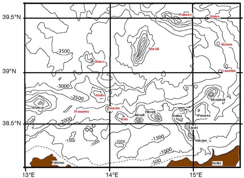
Italiano: Arco Eoliano, comprese le linee di costa e isobate ogni 500 metri. In grigio, accompagnata da scritta del nome in nero: le isole Eolie (oltre all'isola di Ustica alle coordinate 38,5°N e 13°E). Con scritta del nome in rosso: seamount dell'arco eoliano. Area in marrone: la Sicilia. Ridisegnata e modificata da una immagine tratta dal lavoro di Paolo Favali et al., Annals of Geophysics 49(2/3), p. 794, 2006.
English: Aeolian arc, including coastline and depth contour lines for every 500 meters. The Aeolian islands are shown in gray (surface) with their respective names in black (including the island of Ustica at coordinates 38.5°N and 13°E). The names of Aeolian arc seamounts are shown in red. The brown area is Sicily. Redesigned and modified from an image taken from the work of Paolo Favali et al., Annals of Geophysics 49(2/3), p. 794, 2006.
Deutsch: Äolischer Bogen mit Küstenlinien und Tiefenlinien alle 500 Meter. Die Äolischen Inseln sind grau (Oberfläche) mit ihren jeweiligen Namen in Schwarz dargestellt (einschließlich der Insel Ustica); Die Namen der Tiefseeberge des Äolischen Bogens sind rot dargestellt. Der braune Bereich ist Sizilien. Neu gestaltet und modifiziert anhand eines Bildes aus der Arbeit von Paolo Favali et al., Annals of Geophysics 49(2/3), p. 794, 2006.
Date
Source Own work
Author Ferdinando chiodo

Licensing

Public domain I, the copyright holder of this work, release this work into the public domain. This applies worldwide.
In some countries this may not be legally possible; if so:
I grant anyone the right to use this work for any purpose, without any conditions, unless such conditions are required by law.

Captions

Add a one-line explanation of what this file represents

Items portrayed in this file

depicts

29 September 2007

image/jpeg

d4657c831b2dc4a87620b8431c2fcd4805ea4733

143,093 byte

676 pixel

925 pixel

File history

Click on a date/time to view the file as it appeared at that time.

Date/TimeThumbnailDimensionsUserComment
current09:46, 30 September 2007Thumbnail for version as of 09:46, 30 September 2007925 × 676 (140 KB)F.chiodo{{Information |Description=Arco Eoliano, comprese le linee di costa e isobate ogni 500 metri. In grigio, accompagnata da scritta del nome in rosso: le isole Eolie. Con scritta del nome in nero: seamount dell'arco eoliano. Ridisegnata e modificata da immag

The following 2 pages use this file:

Global file usage

The following other wikis use this file:

Metadata