
File:Allgaü 1800.jpg
No higher resolution available.
Allgaü_1800.jpg (649 × 516 pixels, file size: 129 KB, MIME type: image/jpeg)
| This is a file from the Wikimedia Commons. Information from its description page there is shown below. Commons is a freely licensed media file repository. You can help. |
Summary
| Description |
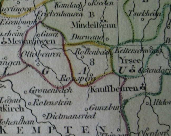
English: Section of a map showing part of the Allgaü region (Swabia) with the territories of the Imperial abbeys of Ottobeuren and Irsee and the Imperial cities of Memmingen and Kaufbeuren. Part of the Princely abbey of Kempten and the Bavarian exclave of Mindelheim are also visible. Cropped from an 1802 map of the Swabian Circle by British map publisher Robert Wilkinson. |
| Date | |
| Source | Own work |
| Author | Lubiesque |
Licensing
I, the copyright holder of this work, hereby publish it under the following license:
This file is licensed under the Creative Commons Attribution-Share Alike 4.0 International license.
- You are free:
- to share – to copy, distribute and transmit the work
- to remix – to adapt the work
- Under the following conditions:
- attribution – You must give appropriate credit, provide a link to the license, and indicate if changes were made. You may do so in any reasonable manner, but not in any way that suggests the licensor endorses you or your use.
- share alike – If you remix, transform, or build upon the material, you must distribute your contributions under the same or compatible license as the original.
File history
Click on a date/time to view the file as it appeared at that time.
| Date/Time | Thumbnail | Dimensions | User | Comment | |
|---|---|---|---|---|---|
| current | 22:02, 22 July 2015 | | 649 × 516 (129 KB) | Lubiesque | User created page with UploadWizard |
File usage
The following pages on the English Wikipedia use this file (pages on other projects are not listed):