
File:Arkansas Scout Map.png

Size of this preview: 717 × 599 pixels. Other resolutions: 287 × 240 pixels | 574 × 480 pixels | 773 × 646 pixels.
Original file (773 × 646 pixels, file size: 97 KB, MIME type: image/png)
| This is a file from the Wikimedia Commons. Information from its description page there is shown below. Commons is a freely licensed media file repository. You can help. |
Summary
| Description |
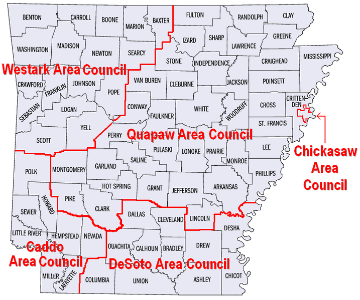
English: Map of Boys Scout councils in Arkansas |
| Date | (UTC) |
| Source |
This file was derived from: Arkansas counties map.png: |
| Author |
|
| This is a retouched picture, which means that it has been digitally altered from its original version. Modifications: Added Scout council boarders and colored districts. The original can be viewed here: Arkansas counties map.png:
|
Licensing
- Derivative work
I, the copyright holder of this work, hereby publish it under the following license:
This file is licensed under the Creative Commons Attribution 3.0 Unported license.
- You are free:
- to share – to copy, distribute and transmit the work
- to remix – to adapt the work
- Under the following conditions:
- attribution – You must give appropriate credit, provide a link to the license, and indicate if changes were made. You may do so in any reasonable manner, but not in any way that suggests the licensor endorses you or your use.
- Original upload
This image or file is a work of a United States Census Bureau employee, taken or made as part of that person's official duties. As a work of the U.S. federal government, the image is in the public domain.
|
 |
File history
Click on a date/time to view the file as it appeared at that time.
| Date/Time | Thumbnail | Dimensions | User | Comment | |
|---|---|---|---|---|---|
| current | 16:09, 27 February 2013 | | 773 × 646 (97 KB) | ARTEST4ECHO | Added Council Names |
| 15:21, 27 February 2013 |  | 735 × 653 (83 KB) | ARTEST4ECHO | Change mind. Am going to do thing differently. | |
| 20:29, 22 February 2013 |  | 735 × 648 (87 KB) | ARTEST4ECHO | == {{int:filedesc}} == {{Information |Description={{en|1=Map of council and district locations in Arkansas}} |Source={{Derived from|82ARGovCounties.PNG|display=50}} |Date=2013-02-22 20:27 (UTC) |Author=*File:82ARGovCounties.PNG: [[User:Tennisace1... |
File usage
The following pages on the English Wikipedia use this file (pages on other projects are not listed):