Jump to content

File:Arsia Mons PIA02804.jpg

Page contents not supported in other languages.
This is a file from the Wikimedia Commons
From Wikipedia, the free encyclopedia

Arsia_Mons_PIA02804.jpg (524 × 462 pixels, file size: 52 KB, MIME type: image/jpeg)

Summary

Description

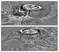
Two views of Arsia Mons, based on Viking orbiter imagery and Mars Global Surveyor elevation data, from the south (top) and north (bottom).

Arsia Mons is the southernmost of the Tharsis Montes. It is depicted using a Viking image mosaic draped over MOLA topography. The topography shows the caldera structure and the massive flank breakouts that produced two major side lobes on opposite sides of the volcano. The vertical exaggeration is 10:1.
Source http://photojournal.jpl.nasa.gov/catalog/PIA02804
Author NASA/MOLA Science Team
This image or video was catalogued by Jet Propulsion Laboratory of the United States National Aeronautics and Space Administration (NASA) under Photo ID: PIA02804.

This tag does not indicate the copyright status of the attached work. A normal copyright tag is still required. See Commons:Licensing.
Other languages:

Licensing

Public domain This file is in the public domain in the United States because it was solely created by NASA. NASA copyright policy states that "NASA material is not protected by copyright unless noted". (See Template:PD-USGov, NASA copyright policy page or JPL Image Use Policy.)
Warnings:

Original upload log

(All user names refer to en.wikipedia)

  • 2006-07-14 23:41 Cuppysfriend 291×256×8 (17193 bytes) Two processed images of [[Arsia Mons]] taken by the [[Mars Global Surveyor]] Orbiter. Original Caption Released with Image: Two views of Arsia Mons, the southern most of the [[Tharsis montes]], shown as topography draped over a Viking image mosaic. MOLA

Captions

Add a one-line explanation of what this file represents

在此檔案描寫的項目

depicts

image/jpeg

1a90dde2a27c8bad1cbd516e472883c055379d62

52,900 byte

462 pixel

524 pixel

File history

Click on a date/time to view the file as it appeared at that time.

Date/TimeThumbnailDimensionsUserComment
current07:24, 15 September 2012Thumbnail for version as of 07:24, 15 September 2012524 × 462 (52 KB)WolfmanSFhigher resolution version of same image
02:59, 11 August 2007Thumbnail for version as of 02:59, 11 August 2007291 × 256 (17 KB)Webaware{{Information |Description=Two processed images of en:Arsia Mons taken by the en:Mars Global Surveyor Orbiter. Original Caption Released with Image: Two views of Arsia Mons, the southern most of the en:Tharsis Montes, shown as topography

The following page uses this file:

Global file usage

The following other wikis use this file: