
File:Atascadero-creek-north-of-more-mesa.jpg

Size of this preview: 800 × 548 pixels. Other resolutions: 320 × 219 pixels | 640 × 439 pixels | 1,024 × 702 pixels | 1,280 × 877 pixels | 2,802 × 1,920 pixels.
Original file (2,802 × 1,920 pixels, file size: 3.21 MB, MIME type: image/jpeg)
| This is a file from the Wikimedia Commons. Information from its description page there is shown below. Commons is a freely licensed media file repository. You can help. |
Summary
| Description |
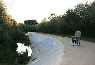
English: This view of Atascadero Creek runs along the north edge of More Mesa in Santa Barbara, California.
|
| Date | |
| Source | Own work |
| Author | DillyLynn |
| Camera location | | View this and other nearby images on: OpenStreetMap |
|---|

|
The copyright holder of this image hereby irrevocably releases all rights to it, allowing it to be freely reproduced, distributed, transmitted, used, modified, built upon, or otherwise exploited in any way by anyone for any purpose, commercial or non-commercial. However, as a courtesy, a link back to Discover-Santa-Barbara would be appreciated.
|
Licensing
I, the copyright holder of this work, hereby publish it under the following licenses:
This file is licensed under the Creative Commons Attribution-Share Alike 3.0 Unported license.
- You are free:
- to share – to copy, distribute and transmit the work
- to remix – to adapt the work
- Under the following conditions:
- attribution – You must give appropriate credit, provide a link to the license, and indicate if changes were made. You may do so in any reasonable manner, but not in any way that suggests the licensor endorses you or your use.
- share alike – If you remix, transform, or build upon the material, you must distribute your contributions under the same or compatible license as the original.

|
Permission is granted to copy, distribute and/or modify this document under the terms of the GNU Free Documentation License, Version 1.2 or any later version published by the Free Software Foundation; with no Invariant Sections, no Front-Cover Texts, and no Back-Cover Texts. A copy of the license is included in the section entitled GNU Free Documentation License. |
You may select the license of your choice.
File history
Click on a date/time to view the file as it appeared at that time.
| Date/Time | Thumbnail | Dimensions | User | Comment | |
|---|---|---|---|---|---|
| current | 20:33, 29 October 2010 | | 2,802 × 1,920 (3.21 MB) | DillyLynn | {{Information |Description={{en|1=This view of Atascadero Creek runs along the north edge of More Mesa. Here you feel like you're in the middle of nowhere, but civilization is just steps away. This nature trail is popular with pedestrians, cyclists and eq |
File usage
The following pages on the English Wikipedia use this file (pages on other projects are not listed):
Global file usage
The following other wikis use this file:
- Usage on ceb.wikipedia.org
- Usage on www.wikidata.org