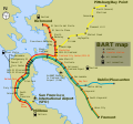
File:Bart-map.svg
Appearance

Size of this PNG preview of this SVG file: 563 × 525 pixels. Other resolutions: 257 × 240 pixels | 515 × 480 pixels | 824 × 768 pixels | 1,098 × 1,024 pixels | 2,196 × 2,048 pixels.
Original file (SVG file, nominally 563 × 525 pixels, file size: 122 KB)
File history
Click on a date/time to view the file as it appeared at that time.
| Date/Time | Thumbnail | Dimensions | User | Comment | |
|---|---|---|---|---|---|
| current | 23:29, 13 February 2009 |  | 563 × 525 (122 KB) | Kevin chen2003 | Reverted to version as of 19:32, 14 July 2008 (i uploaded the wrong file) |
| 23:29, 13 February 2009 |  | 563 × 525 (124 KB) | Kevin chen2003 | Capitalized the 'M' in 'BART Map' | |
| 19:32, 14 July 2008 |  | 563 × 525 (122 KB) | ChrisRuvolo | fix spelling: "Layfayette" to "Lafayette" | |
| 14:22, 27 May 2008 |  | 563 × 525 (122 KB) | ChrisRuvolo | update: fix fonts, use AIGA symbols, update penninsula routes | |
| 20:28, 20 June 2006 |  | 563 × 525 (126 KB) | ChrisRuvolo | changed color of land to better contrast yellow line | |
| 16:38, 13 June 2006 |  | 563 × 525 (125 KB) | ChrisRuvolo | correct spelling "Pittsburg" | |
| 19:56, 9 June 2006 |  | 563 × 525 (125 KB) | ChrisRuvolo | fix legend box text label "BART map" centering and size | |
| 22:48, 5 June 2006 |  | 563 × 525 (126 KB) | ChrisRuvolo | thicken route lines | |
| 22:42, 5 June 2006 |  | 563 × 525 (126 KB) | ChrisRuvolo | BART (en:Bay Area Rapid Transit) map, based on SVG map by User:Finlay_McWalter for Caltrain. Image:Wfm caltrain.png, with source Image:Wfm caltrain.png/source. |
File usage
The following page uses this file:

