
File:Barton Upon Humber, St Mary's church (26965046349).jpg

Original file (4,028 × 2,830 pixels, file size: 7.57 MB, MIME type: image/jpeg)
| This is a file from the Wikimedia Commons. Information from its description page there is shown below. Commons is a freely licensed media file repository. You can help. |
.jpg)
Summary
| Description |
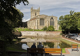
Barton on Humber has two churches located close to each other, the older being Saint Peter's which dates from the late 10th century, and is mentioned in the Domesday Book of 1086. It is unsure why a second church was built, although Saint Peter's was much smaller at the time, and the town was prosperous. St Mary's dates from the 12th century onwards, and has a nave with north and south aisles, a western tower, a chancel with south Chapel, and a south porch with parvis. The north arcade dates from the mid to late 12th century, and is of five bays plus a taller, later eastern arch. The piers are circular and the round arches have zigzag decoration. The south arcade is of four bays and dates from circa 1300. It has octagonal columns similar to those in Lincoln Cathedral, topped with water leaf capitals. Both the aisles were later enlarged. The tower dates from the 13th century, and has decorated parapets with eight pinnacles from a later date. There was initially a spire on top. The tower arch has stiff leaf capitals and keeled shafts. The south porch has a reset early 13th century archway, and an upper chamber with a door high in the nave, once reached by a stairway. In the 14th century the south chapel was built with a three bay arcade towards the chancel. The capitals contain a number of green men, many of its windows are reused In the 15th century a clerestory was added to the nave. The east window of the chancel was reduced in height when the gabled roof was lowered. There is a brass from the 15th century in the chancel floor and the remains of a 17th-century monument with only a black marble column still standing. There is a three manual organ by Forster and Andrews. Most of the windows are clear glass. |
| Date | |
| Source | Barton Upon Humber, St Mary's church |
| Author | Jules & Jenny from Lincoln, UK |
| Camera location | | View this and other nearby images on: OpenStreetMap |
|---|
.jpg¶ms=053.684483_N_-000.436556_E_globe:Earth_type:camera_source:Flickr_&language=en)
Licensing
- You are free:
- to share – to copy, distribute and transmit the work
- to remix – to adapt the work
- Under the following conditions:
- attribution – You must give appropriate credit, provide a link to the license, and indicate if changes were made. You may do so in any reasonable manner, but not in any way that suggests the licensor endorses you or your use.
| This image was originally posted to Flickr by Jules & Jenny at https://flickr.com/photos/78914786@N06/26965046349 (archive). It was reviewed on 6 August 2018 by FlickreviewR 2 and was confirmed to be licensed under the terms of the cc-by-2.0. |
File history
Click on a date/time to view the file as it appeared at that time.
| Date/Time | Thumbnail | Dimensions | User | Comment | |
|---|---|---|---|---|---|
| current | 01:15, 6 August 2018 | | 4,028 × 2,830 (7.57 MB) | Tm | Transferred from Flickr via #flickr2commons |
.jpg)