
File:Battle of Gallipoli - map of Turkish dispositions, April 1915.jpg
Size of this preview: 573 × 599 pixels. Other resolutions: 229 × 240 pixels | 459 × 480 pixels | 734 × 768 pixels | 979 × 1,024 pixels | 1,958 × 2,048 pixels | 4,252 × 4,448 pixels.
Original file (4,252 × 4,448 pixels, file size: 12.5 MB, MIME type: image/jpeg)
| This is a file from the Wikimedia Commons. Information from its description page there is shown below. Commons is a freely licensed media file repository. You can help. |
| new file | This image is a JPEG version of the original PNG image at File: Battle of Gallipoli - map of Turkish dispositions, April 1915.png.
Generally, this JPEG version should be used when displaying the file from Commons, in order to reduce the file size of thumbnail images. However, any edits to the image should be based on the original PNG version in order to prevent generation loss, and both versions should be updated. Do not make edits based on this version. See here for more information. |
| Description |
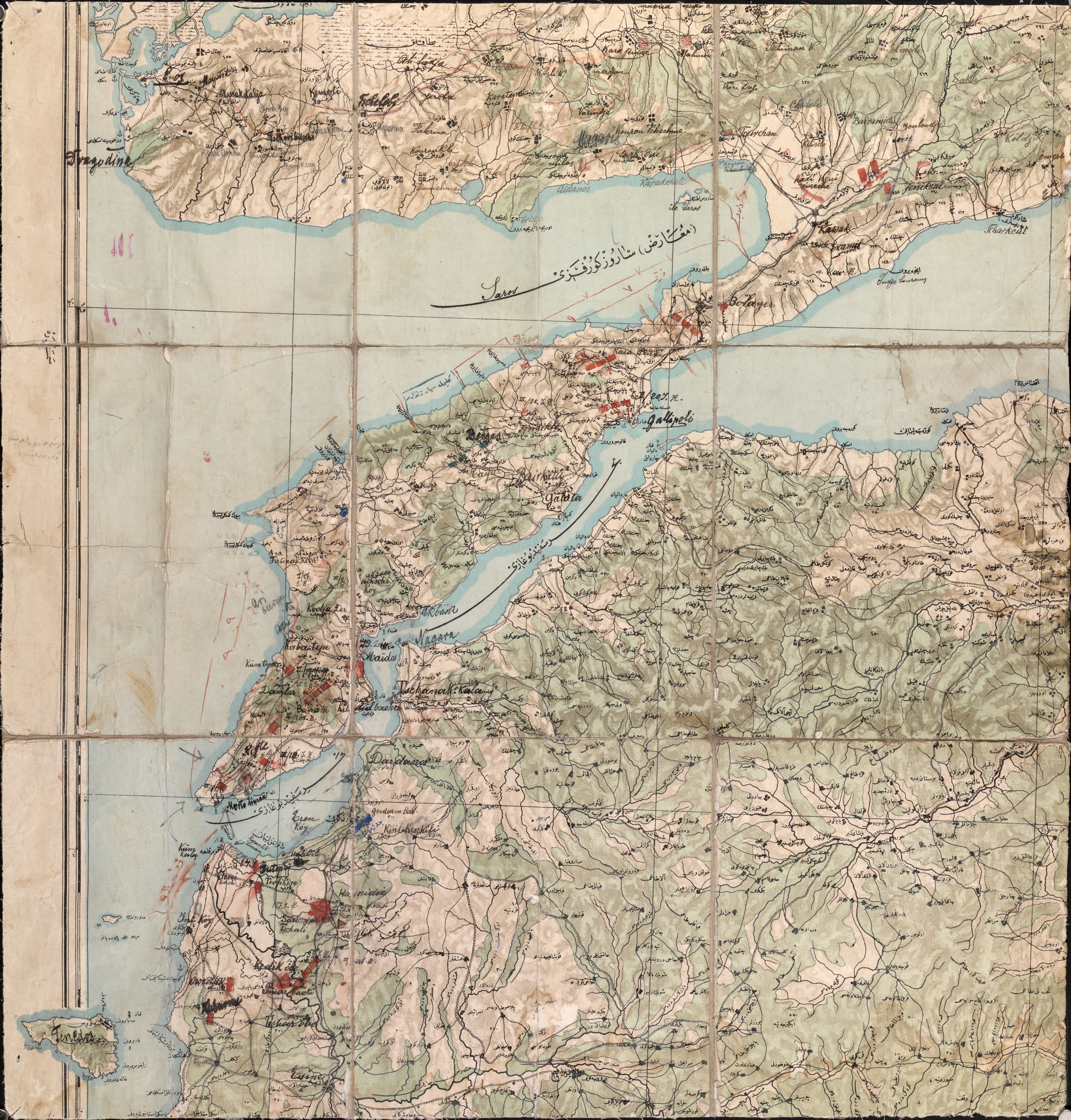
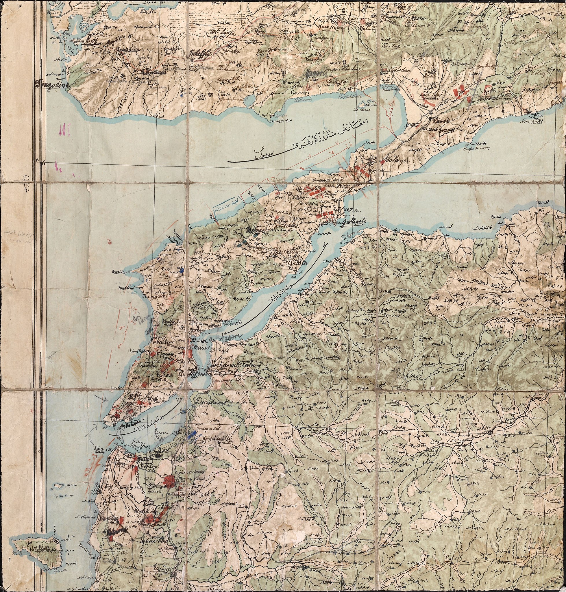
English: This map shows Turkish dispositions before the landings on 25 April 1915. The commander of the Ottoman Turkish Fifth Army, Otto Liman von Sanders, believed the British would attack at Bulair (called Bolayer on the map) at the narrowest point of the peninsula or on the Asiatic side of the coast across from the island of Tenedos, which was occupied by the British. This map shows how Liman von Sanders distributed his troops in anticipation of the allied invasion. A third of his forces was located on the Asiatic side of the cost, another third was located at Bulair, while the final third was distributed around the tip of the peninsula, with one division under Lieutenant Colonel Mustafa Kemal (later Atatürk, the first president of modern Turkey) based at Boghali and the other division based to the south of Gaba Tepe (also called Kaba Tepe). No Turkish forces are indicated on the map around Ari Burnu, where the Australians and New Zealanders landed on 25 April, although there are some defences indicated at Gaba Tepe, further south. Ari Burnu is not noted on this map at all in Ottoman Turkish (Arabic), and while most place names have been transliterated from Ottoman Turkish into Latin script in ink, the notation “Ari Burnu”, written on the map in pencil, was added at a later date, along with three pencilled arrows showing the area where the British landed at Cape Helles. The back of the map is signed “Liman von Sanders V Armee”. |
|||
| Date | ||||
| Source |
Australian War Memorial reference code: G7432.G1 S65 VII.1 url: http://www.awm.gov.au/exhibitions/gmaps/turkish/gallipoli.asp |
|||
| Author | Turkish Mapping Directorate | |||
| Permission (Reusing this file) |
|
.svg)
File history
Click on a date/time to view the file as it appeared at that time.
| Date/Time | Thumbnail | Dimensions | User | Comment | |
|---|---|---|---|---|---|
| current | 15:13, 21 June 2011 | | 4,252 × 4,448 (12.5 MB) | Labattblueboy | {{JPEG version of PNG|Battle of Gallipoli - map of Turkish dispositions, April 1915.png}} {{Information |Description={{en|This map shows Turkish dispositions before the landings on 25 April 1915. The commander of the Ottoman Turkish Fifth Army, Otto Liman |
File usage
The following pages on the English Wikipedia use this file (pages on other projects are not listed):