
File:Bosnia and Herzegovina Political.png

Size of this preview: 631 × 599 pixels. Other resolutions: 253 × 240 pixels | 505 × 480 pixels | 808 × 768 pixels | 1,078 × 1,024 pixels | 1,600 × 1,520 pixels.
Original file (1,600 × 1,520 pixels, file size: 201 KB, MIME type: image/png)
| This is a file from the Wikimedia Commons. Information from its description page there is shown below. Commons is a freely licensed media file repository. You can help. |

|
File:Municipalities and regions of Bosnia and Herzegovina.svg is a vector version of this file. It should be used in place of this PNG file when not inferior.
File:Bosnia and Herzegovina Political.png → File:Municipalities and regions of Bosnia and Herzegovina.svg
For more information, see Help:SVG. |
 |
| Description |
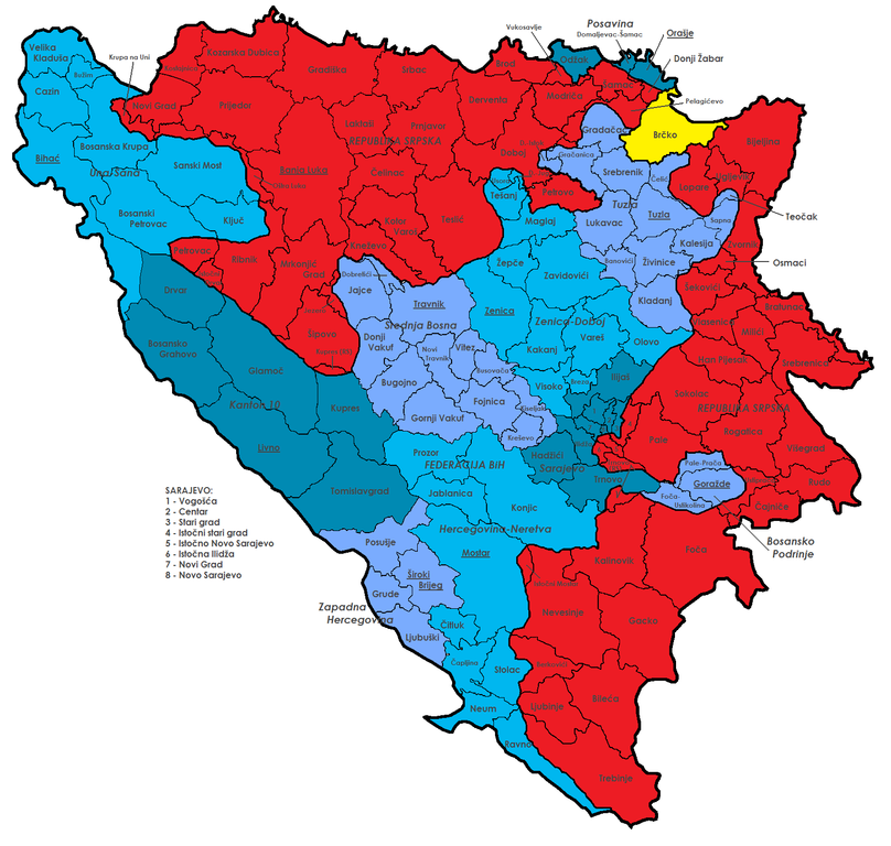
English: Map of the political division of Bosnia and Herzegovina; shows Federation Bih (blue) with cantons (different colours), Republika Srpska (red), Brčko district (yellow) and all municipalities with their official names.
Deutsch: Diese Karte zeigt die Verwaltungsgliederung von Bosnien und Herzegowina. Dargestellt sind die Föderation BiH (blau) mit ihren Kantonen (verschiedene Schattierungen) und deren Hauptstädten, die Republika Srpska (rot), der Brčko-Distrikt (gelb) und alle Gemeinden mit ihren offiziellen Namen. |
| Date | |
| Source | own work, based on File:BH municipality location.gif |
| Author | j.budissin (Julian Nitzsche) |
| Other versions | Version without text |
Licensing
I, the copyright holder of this work, hereby publish it under the following licenses:

|
Permission is granted to copy, distribute and/or modify this document under the terms of the GNU Free Documentation License, Version 1.2 or any later version published by the Free Software Foundation; with no Invariant Sections, no Front-Cover Texts, and no Back-Cover Texts. A copy of the license is included in the section entitled GNU Free Documentation License. |
This file is licensed under the Creative Commons Attribution-Share Alike Attribution-Share Alike 4.0 International, 3.0 Unported, 2.5 Generic, 2.0 Generic and 1.0 Generic license.
- You are free:
- to share – to copy, distribute and transmit the work
- to remix – to adapt the work
- Under the following conditions:
- attribution – You must give appropriate credit, provide a link to the license, and indicate if changes were made. You may do so in any reasonable manner, but not in any way that suggests the licensor endorses you or your use.
- share alike – If you remix, transform, or build upon the material, you must distribute your contributions under the same or compatible license as the original.
You may select the license of your choice.
File history
Click on a date/time to view the file as it appeared at that time.
| Date/Time | Thumbnail | Dimensions | User | Comment | |
|---|---|---|---|---|---|
| current | 16:15, 18 July 2009 | | 1,600 × 1,520 (201 KB) | J budissin | {{Information |Description= {{en|Map of the political division of Bosnia and Herzegovina; shows Federation Bih (blue) with cantons (different colours), Republika Srpska (red), Brčko district (yellow) and all municipalities with their official names.}} {{ |
File usage
No pages on the English Wikipedia use this file (pages on other projects are not listed).
Global file usage
The following other wikis use this file:
- Usage on an.wikipedia.org
- Usage on bs.wikipedia.org
- Usage on ca.wikipedia.org
- Usage on cs.wikipedia.org
- Usage on de.wikipedia.org
- Bosnien und Herzegowina
- Republika Srpska
- Diskussion:Republika Srpska
- Liste der Gemeinden von Bosnien und Herzegowina
- Benutzer:J budissin/BiH
- Benutzer Diskussion:Mazbln/Archiv 2009
- Benutzer Diskussion:20percent/Archiv/2009
- Wikipedia:Kartenwerkstatt/Archiv/2013-08
- Vorlage:Imagemap BosnienundHerzegowina Gemeinden
- Referendum über den Nationalfeiertag in der Republika Srpska 2016
- Benutzer:J budissin/Općine
- Usage on de.wikibooks.org
- Usage on es.wikipedia.org
- Usage on frr.wikipedia.org
- Usage on fr.wikipedia.org
- Usage on hr.wikipedia.org
- Usage on it.wikipedia.org
- Usage on nl.wikipedia.org
- Usage on no.wikipedia.org
- Usage on rm.wikipedia.org
- Usage on ru.wikipedia.org
- Usage on stq.wikipedia.org
- Usage on uk.wikipedia.org
- Usage on www.wikidata.org