
File:British Overseas Territories.svg

Size of this PNG preview of this SVG file: 800 × 591 pixels. Other resolutions: 320 × 237 pixels | 640 × 473 pixels | 1,024 × 757 pixels | 1,280 × 946 pixels | 2,560 × 1,892 pixels | 1,652 × 1,221 pixels.
Original file (SVG file, nominally 1,652 × 1,221 pixels, file size: 732 KB)
| This is a file from the Wikimedia Commons. Information from its description page there is shown below. Commons is a freely licensed media file repository. You can help. |
Summary
| Description |
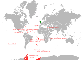
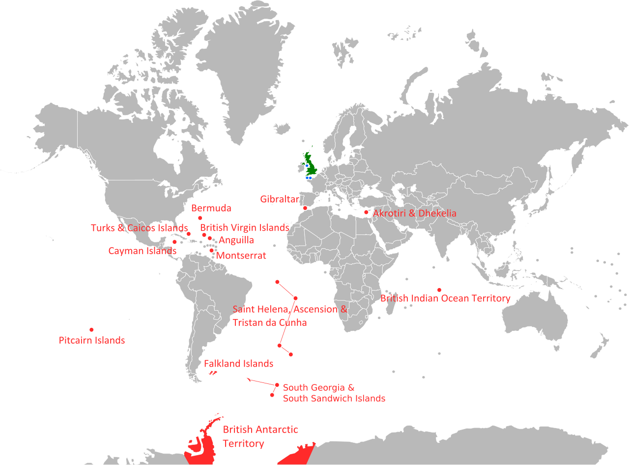
English: map showing the location of current British Overseas Territories. |
| Date | |
| Source | Own work |
| Author | Geord0 |
| Other versions |
|

Licensing
I, the copyright holder of this work, hereby publish it under the following licenses:
This file is licensed under the Creative Commons Attribution-Share Alike 3.0 Unported license.
- You are free:
- to share – to copy, distribute and transmit the work
- to remix – to adapt the work
- Under the following conditions:
- attribution – You must give appropriate credit, provide a link to the license, and indicate if changes were made. You may do so in any reasonable manner, but not in any way that suggests the licensor endorses you or your use.
- share alike – If you remix, transform, or build upon the material, you must distribute your contributions under the same or compatible license as the original.

|
Permission is granted to copy, distribute and/or modify this document under the terms of the GNU Free Documentation License, Version 1.2 or any later version published by the Free Software Foundation; with no Invariant Sections, no Front-Cover Texts, and no Back-Cover Texts. A copy of the license is included in the section entitled GNU Free Documentation License. |
You may select the license of your choice.
File history
Click on a date/time to view the file as it appeared at that time.
| Date/Time | Thumbnail | Dimensions | User | Comment | |
|---|---|---|---|---|---|
| current | 11:33, 16 April 2012 | | 1,652 × 1,221 (732 KB) | Hairy Dude | correct name of the South Sandwich Islands |
| 03:48, 30 August 2011 |  | 1,652 × 1,221 (776 KB) | Geord0 | spelling | |
| 16:26, 29 August 2011 |  | 1,652 × 1,221 (764 KB) | Geord0 | colour changed to them as previously projection on other map, to deter confusion between the territories and the UK | |
| 16:09, 29 August 2011 |  | 1,652 × 1,221 (764 KB) | Geord0 | better, more recent map | |
| 18:30, 15 May 2011 |  | 999 × 553 (659 KB) | Geord0 | changes to the Svalbard sea border | |
| 18:27, 15 May 2011 |  | 999 × 553 (659 KB) | Geord0 | changes to some northern borders | |
| 16:27, 15 May 2011 |  | 999 × 553 (656 KB) | Geord0 | Reverted to version as of 16:20, 15 May 2011 | |
| 16:20, 15 May 2011 |  | 999 × 553 (656 KB) | Geord0 | Reverted to version as of 16:20, 15 May 2011 | |
| 16:20, 15 May 2011 |  | 999 × 553 (656 KB) | Geord0 | Reverted to version as of 16:19, 15 May 2011 | |
| 16:20, 15 May 2011 |  | 999 × 553 (656 KB) | Geord0 | added labels |
File usage
The following pages on the English Wikipedia use this file (pages on other projects are not listed):
Global file usage
The following other wikis use this file:
- Usage on sr.wikipedia.org
- Usage on su.wikipedia.org