Jump to content

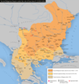
File:Bulgaria-Ivan Asen 2.png

Page contents not supported in other languages.
This is a file from the Wikimedia Commons
From Wikipedia, the free encyclopedia

Original file (1,982 × 2,113 pixels, file size: 1.04 MB, MIME type: image/png)

Summary

Description
English: Second Bulgarian Empire under rule of tsar Ivan Assen II.
Български: Втората българска държава под управлението на цар Иван Асен ІІ.


Основана на:
1. Карта "България през царуването на Иван Асен ІІ (1230-1241)" в книгата " Политическа география на средновековната българска държава. Втора част (1186—1396)", Петър Коледаров, Издателство на Българска Академия на Науките, София, 1989 г. [1]
2. Карта "България (1185-1241)" в "Атлас по история и цивилизация за 11 клас ", инж. Любен Цветков, инж. Красимир Андреев, издателство "Картография", София, 2007 г. [2]
3. Карта "България през първата половина на XIII в.", страница 168, в "История на България в четиринадесет тома. Том 3, Втора българска държава", Издателство на Българската академия на науките, София, 1982 г.
4. Карта "Могъщество на Втората българска държава (1187-1241)", страница 14, в "Атлас по родинознание", МССУ - Главно управление по геодезия, картография и кадастър, КИПП по картография, София, 1984 г.


Baset on:
1. Map "Bulgaria during the reign of Ivan Assen II (1230-1241)" in the book "Political Geography of the Medieval Bulgarian State. Part Two (1186-1396)", Petar Koledarov, Publishing House of the Bulgarian Academy of Sciences, Sofia, 1989. [3]
2. Map "Bulgaria (1185-1241)" in "Atlas of History and Civilization for 11th grade", Lyuben Tsvetkov and Krassimir Andreev, publishing house "Cartography", Sofia, 2007 [4]
3. Map "Bulgaria in the first half of the XIII century.", page 168, in "History of Bulgaria in fourteen volumes. Volume 3, Second Bulgarian State", Publishing House of the Bulgarian Academy of Sciences, Sofia, 1982.
4. Map "Power of the Second Bulgarian State (1187-1241)", page 14, in "Atlas of Homeland Studies", IASB - General Directorate of Geodesy, Cartography and Cadastre, Instrumentation for Cartography, Sofia, 1984
Date
Source Own work
Author Kandi

Licensing

I, the copyright holder of this work, hereby publish it under the following licenses:
GNU head Permission is granted to copy, distribute and/or modify this document under the terms of the GNU Free Documentation License, Version 1.2 or any later version published by the Free Software Foundation; with no Invariant Sections, no Front-Cover Texts, and no Back-Cover Texts. A copy of the license is included in the section entitled GNU Free Documentation License.
w:en:Creative Commons
attribution share alike
This file is licensed under the Creative Commons Attribution-Share Alike 4.0 International, 3.0 Unported, 2.5 Generic, 2.0 Generic and 1.0 Generic license.
You are free:
  • to share – to copy, distribute and transmit the work
  • to remix – to adapt the work
Under the following conditions:
  • attribution – You must give appropriate credit, provide a link to the license, and indicate if changes were made. You may do so in any reasonable manner, but not in any way that suggests the licensor endorses you or your use.
  • share alike – If you remix, transform, or build upon the material, you must distribute your contributions under the same or compatible license as the original.
You may select the license of your choice.

Captions

Add a one-line explanation of what this file represents

Obiekty przedstawione na tym zdjęciu

depicts

8 January 2008

image/png

e353a1e662f389d96efa6663d221c5d1a3aed361

1,095,207 byte

2,113 pixel

1,982 pixel

File history

Click on a date/time to view the file as it appeared at that time.

Date/TimeThumbnailDimensionsUserComment
current16:11, 16 November 2022Thumbnail for version as of 16:11, 16 November 20221,982 × 2,113 (1.04 MB)KandiReverted to version as of 16:45, 20 December 2019 (UTC)
15:37, 16 November 2022Thumbnail for version as of 15:37, 16 November 20221,982 × 2,113 (1.07 MB)Gyalu22Sourced change
16:45, 20 December 2019Thumbnail for version as of 16:45, 20 December 20191,982 × 2,113 (1.04 MB)KandiReverted to version as of 14:10, 24 April 2016 (UTC)
13:50, 20 December 2019Thumbnail for version as of 13:50, 20 December 20191,982 × 2,113 (1.07 MB)Julieta39Details according with Victor Spinei, "Moldavia in the 11th-14th Centuries", Academia Româna Publ., Bucharest 1986, "The Great Migrations in the East and South East of Europe from the Ninth to the Thirteenth Century", Institutul Cultural Român, Cluj 2003, ISBN 9789738589452; second issue: Hakkert Publisher, Amsterdam 2006, ISBN 90-256-1207-5 (vol. 1), ISBN 90-256-1214-8 (vol. 2), and "Romanians and Turkic Nomads North of the Danube Delta from the Tenth to the Mid-Thirteenth Century", Brill pu...
14:10, 24 April 2016Thumbnail for version as of 14:10, 24 April 20161,982 × 2,113 (1.04 MB)Kandinew version
12:08, 8 January 2008Thumbnail for version as of 12:08, 8 January 2008761 × 1,029 (636 KB)Kandi{{Information |Description=Bulgaria-Ivan Asen 2 |Source=self-made |Date=8-1-2008 |Author= Kandi |Permission= |other_versions= }}
No pages on the English Wikipedia use this file (pages on other projects are not listed).

Global file usage

The following other wikis use this file:

Metadata