
File:Bulgaria in 1879 geographic map-es.svg

Size of this PNG preview of this SVG file: 752 × 600 pixels. Other resolutions: 301 × 240 pixels | 602 × 480 pixels | 963 × 768 pixels | 1,280 × 1,021 pixels | 2,560 × 2,043 pixels | 2,256 × 1,800 pixels.
Original file (SVG file, nominally 2,256 × 1,800 pixels, file size: 16.57 MB)
| This is a file from the Wikimedia Commons. Information from its description page there is shown below. Commons is a freely licensed media file repository. You can help. |
Summary
| Description |
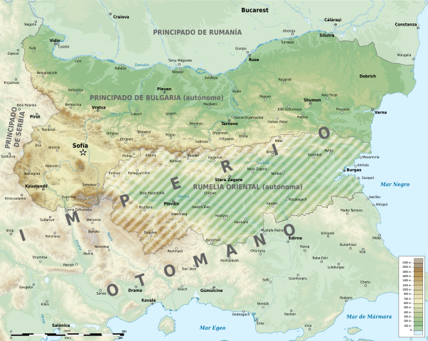
English: The Bulgarian autonomous provinces of the Ottoman Empire between 1879 and 1885: the Principality of Bulgaria and Eastern Rumelia as defined at the Congress of Berlin. |
| Source | File:Bulgaria_in_1879_geographic_map-bg.svg |
| Author | Rowanwindwhistler |
| Other versions |
This file was derived from: Bulgaria in 1879 geographic map-bg.svg |
Licensing
This file is licensed under the Creative Commons Attribution-Share Alike 4.0 International license.
- You are free:
- to share – to copy, distribute and transmit the work
- to remix – to adapt the work
- Under the following conditions:
- attribution – You must give appropriate credit, provide a link to the license, and indicate if changes were made. You may do so in any reasonable manner, but not in any way that suggests the licensor endorses you or your use.
- share alike – If you remix, transform, or build upon the material, you must distribute your contributions under the same or compatible license as the original.
File history
Click on a date/time to view the file as it appeared at that time.
| Date/Time | Thumbnail | Dimensions | User | Comment | |
|---|---|---|---|---|---|
| current | 08:45, 23 February 2019 | | 2,256 × 1,800 (16.57 MB) | Rowanwindwhistler | Uploading a file from a free published source using File Upload Wizard |
File usage
No pages on the English Wikipedia use this file (pages on other projects are not listed).
Global file usage
The following other wikis use this file:
- Usage on es.wikipedia.org