
File:California Freeway and Expressway System.svg

Size of this PNG preview of this SVG file: 514 × 600 pixels. Other resolutions: 206 × 240 pixels | 411 × 480 pixels | 658 × 768 pixels | 878 × 1,024 pixels | 1,755 × 2,048 pixels | 576 × 672 pixels.
Original file (SVG file, nominally 576 × 672 pixels, file size: 1.44 MB)
| This is a file from the Wikimedia Commons. Information from its description page there is shown below. Commons is a freely licensed media file repository. You can help. |
Summary
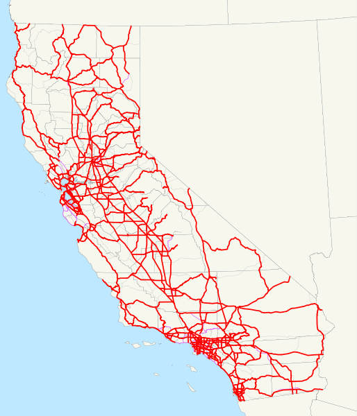
| Description | This is a map of the California Freeway and Expressway System; routes that have been removed from it are in thin purple, and other routes are very thin gray. Email me if you would like a copy of the GIS data I created for the highways. |
| Date | 7 December 2007 (original upload date) |
| Source | No machine-readable source provided. Own work assumed (based on copyright claims). |
| Author | No machine-readable author provided. NE2 assumed (based on copyright claims). |
Licensing
| I, the copyright holder of this work, release this work into the public domain. This applies worldwide. In some countries this may not be legally possible; if so: I grant anyone the right to use this work for any purpose, without any conditions, unless such conditions are required by law. |
File history
Click on a date/time to view the file as it appeared at that time.
| Date/Time | Thumbnail | Dimensions | User | Comment | |
|---|---|---|---|---|---|
| current | 12:33, 6 January 2008 | | 576 × 672 (1.44 MB) | NE2 | Added all other routes to the background. |
| 03:52, 20 December 2007 |  | 576 × 672 (1.4 MB) | NE2 | Fixed SR 111 and SR 86 with respect to SR 86S. | |
| 03:43, 20 December 2007 |  | 576 × 672 (1.4 MB) | NE2 | Modified some positions. | |
| 00:07, 7 December 2007 |  | 576 × 672 (1.32 MB) | NE2 | Thinned the lines. | |
| 00:05, 7 December 2007 |  | 576 × 672 (1.32 MB) | NE2 | == Summary == This is a map of the California Freeway and Expressway System; routes that have been removed from it are in thin purple. Email me if you would like a copy of the GIS data I created for the highways. [[Category:Stat |
File usage
The following pages on the English Wikipedia use this file (pages on other projects are not listed):
Global file usage
The following other wikis use this file:
- Usage on es.wikipedia.org
- Usage on www.wikidata.org
- Usage on zh.wikipedia.org