File:Champlainmap.png
Appearance
Champlainmap.png (465 × 470 pixels, file size: 36 KB, MIME type: image/png)
File history
Click on a date/time to view the file as it appeared at that time.
| Date/Time | Thumbnail | Dimensions | User | Comment | |
|---|---|---|---|---|---|
| current | 23:38, 28 March 2011 |  | 465 × 470 (36 KB) | Gilbertus | retrait du cadre |
| 17:29, 26 July 2006 |  | 500 × 500 (34 KB) | Kmusser | ||
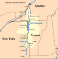
| 17:02, 26 July 2006 |  | 500 × 500 (34 KB) | Kmusser | This is a map showing the Lake Champlain - Richelieu River watershed. I made using USGS, Census Bureau, and [[:en:Digital Chart of |
File usage
The following page uses this file:
Global file usage
The following other wikis use this file:
- Usage on af.wikipedia.org
- Usage on be.wikipedia.org
- Usage on bg.wikipedia.org
- Usage on cs.wikipedia.org
- Usage on de.wikipedia.org
- Usage on eo.wikipedia.org
- Usage on es.wikipedia.org
- Usage on fi.wikipedia.org
- Usage on it.wikipedia.org
- Usage on ja.wikipedia.org
- Usage on nl.wikipedia.org
- Usage on no.wikipedia.org
- Usage on pl.wikipedia.org
- Usage on sk.wikipedia.org
- Usage on sv.wikipedia.org
- Usage on www.wikidata.org
- Usage on zh.wikipedia.org


