
File:Cool lava in Africa's Great Rift Valley.jpg

Size of this preview: 435 × 599 pixels. Other resolutions: 174 × 240 pixels | 349 × 480 pixels | 558 × 768 pixels | 744 × 1,024 pixels | 1,488 × 2,048 pixels | 3,030 × 4,171 pixels.
Original file (3,030 × 4,171 pixels, file size: 7.48 MB, MIME type: image/jpeg)
| This is a file from the Wikimedia Commons. Information from its description page there is shown below. Commons is a freely licensed media file repository. You can help. |
Summary
| Cool lava in Africa’s Great Rift Valley | |
|---|---|
| Photographer |
Envisat satellite |
| Title |
Cool lava in Africa’s Great Rift Valley |
| Description |
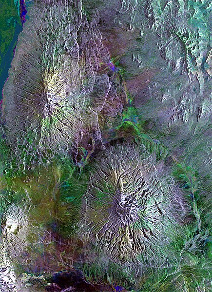
Afrikaans: Hierdie Envisat-radarbeeld toon vulkane wat oor die Tanzaniese landskap versprei is, insluitend die kenmerkende Ol Doinyo Lengai (onder links), in die Groot Skeurvallei van Oos-Afrika. Die Gelai-vulkaan (2942 m) is aan die bokant sigbaar, en die Kitumbeine-vulkaan (1770 m) is suidoos van voorgenoemde. Radarbeelde verteenwoordig oppervlak-terugverstrooiing eerder as gereflekteerde lig, sodat geen ware kleur ter sprake is nie. Hierdie beeld is geskep deur drie Envisat Advanced Synthetic Aperture Radar-verkrygings (3 Februarie 2010, 30 Desember 2009 en 25 November 2009) van dieselfde area te kombineer. Die vals kleure is deur oppervlakveranderinge tussen aftastings veroorsaak.
English: This Envisat radar image captures volcanoes dotted across the landscape in Tanzania, including the distinctive Ol Doinyo Lengai (at lower left), in the Great Rift Valley of East Africa. The Gelai Volcano (2942 m) is visible at the top, and the Kitumbeine Volcano (1770 m) is southeast of Gelai.
Radar images represent surface backscatter rather than reflected light, so there is no colour in a standard radar image. This image was created by combining three Envisat Advanced Synthetic Aperture Radar acquisitions (3 February 2010, 30 December 2009 and 25 November 2009) of the same area. The colours result from changes in the surface between acquisitions. |
| Depicted place | Great Rift Valley |
| Date | between 25 November 2009 and 3 February 2010 |
| Collection | European Space Agency |
| Accession number |
237110 |
| Credit line | ESA |
| Source | http://www.esa.int/spaceinimages/Images/2010/04/Cool_lava_in_Africa_s_Great_Rift_Valley |
Licensing
This file is licensed under the Creative Commons Attribution-ShareAlike 3.0 IGO license.
- You are free:
- to share – to copy, distribute and transmit the work
- to remix – to adapt the work
- Under the following conditions:
- attribution – You must give appropriate credit, provide a link to the license, and indicate if changes were made. You may do so in any reasonable manner, but not in any way that suggests the licensor endorses you or your use.
- share alike – If you remix, transform, or build upon the material, you must distribute your contributions under the same or compatible license as the original.
File history
Click on a date/time to view the file as it appeared at that time.
| Date/Time | Thumbnail | Dimensions | User | Comment | |
|---|---|---|---|---|---|
| current | 05:49, 27 February 2017 | | 3,030 × 4,171 (7.48 MB) | Revent | =={{int:filedesc}}== {{Photograph |photographer = Envisat satellite |title = Cool lava in Africa’s Great Rift Valley |description = {{en|1=This Envisat radar image captures volcanoes dotted across the landscape in Tanzani... |
File usage
The following pages on the English Wikipedia use this file (pages on other projects are not listed):