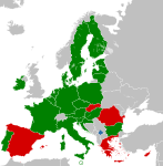
File:EU on kosovo independence.png
Appearance

Size of this preview: 587 × 600 pixels. Other resolutions: 235 × 240 pixels | 593 × 606 pixels.
Original file (593 × 606 pixels, file size: 146 KB, MIME type: image/png)
File history
Click on a date/time to view the file as it appeared at that time.
| Date/Time | Thumbnail | Dimensions | User | Comment | |
|---|---|---|---|---|---|
| current | 02:21, 9 March 2017 |  | 593 × 606 (146 KB) | Geom10 | http://ec.europa.eu/cyprus/turkish_cypriots/index_en.htm "The whole of the island is part of the EU." |
| 04:51, 22 February 2015 |  | 593 × 606 (107 KB) | Leftcry | Fix layout | |
| 13:22, 1 July 2013 |  | 544 × 564 (88 KB) | EmilJ | +Croatia | |
| 14:39, 30 June 2010 |  | 544 × 564 (89 KB) | EmilJ | inexplicably, the Kosovo border was missing | |
| 21:13, 14 November 2009 |  | 544 × 564 (90 KB) | Bugoslav | The file portrayed the borders between non-EU states as non-existing, which is simply wrong. The file also used "screaming" red instead of some more subtle variant of the colour. | |
| 22:27, 19 October 2008 |  | 450 × 422 (14 KB) | SterkeBak | Per talk page | |
| 14:03, 15 October 2008 |  | 450 × 422 (9 KB) | Kanonkas | Rv, take this to the talk. | |
| 10:11, 14 October 2008 |  | 450 × 422 (14 KB) | Avala | I will report you and you will be blocked because Slovakia is not neutral. You can't present a single source for that | |
| 07:12, 14 October 2008 |  | 450 × 422 (9 KB) | Mareklug | um. if you care to, create a graphic without the yellow in the legend, or strip yellow out of this one. but as long as it's here, SVK and GRE are for now fitting yellow. | |
| 19:21, 13 October 2008 |  | 450 × 422 (14 KB) | Avala |
File usage
No pages on the English Wikipedia use this file (pages on other projects are not listed).
Global file usage
The following other wikis use this file:
- Usage on de.wikipedia.org


