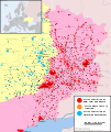
File:East Ukraine conflict (English language version).png
Appearance

Size of this preview: 454 × 599 pixels. Other resolutions: 182 × 240 pixels | 364 × 480 pixels | 582 × 768 pixels | 776 × 1,024 pixels | 2,048 × 2,701 pixels.
Original file (2,048 × 2,701 pixels, file size: 1,012 KB, MIME type: image/png)
File history
Click on a date/time to view the file as it appeared at that time.
| Date/Time | Thumbnail | Dimensions | User | Comment | |
|---|---|---|---|---|---|
| current | 20:22, 5 August 2014 |  | 2,048 × 2,701 (1,012 KB) | Mondolkiri1 | Reverted to version as of 21:56, 3 August 2014 Ukrainian govt forces withdrew again from Yasynuvata http://www.segodnya.ua/regions/donetsk/sily-ato-vyshli-iz-yasinovatoy-na-vremya-evakuacii-mestnogo-naseleniya-542112.html |
| 22:53, 4 August 2014 |  | 2,048 × 2,701 (1,011 KB) | Mondolkiri1 | Yasynuvata taken by government forces: http://zn.ua/UKRAINE/sily-ato-zanyali-gorod-yasinovataya-i-razblokirovali-puti-na-dmitrovku-i-dyakovo-150156_.html (with the help of Google Maps) | |
| 21:56, 3 August 2014 |  | 2,048 × 2,701 (1,012 KB) | Mondolkiri1 | The latest sources indicate that the Savur-Mohyla height is still a combat zone - http://uapress.info/uk/news/show/32932 http://www.spbdnevnik.ru/news/2014-08-02/opolchentsy-okruzhili-krupnuyu-gruppirovku-ukrainskoy-armii-u-toreza-i-shakhterska/ . If i... | |
| 06:08, 3 August 2014 |  | 2,048 × 2,701 (881 KB) | AshFox | updated | |
| 03:18, 3 August 2014 |  | 2,048 × 2,701 (1,016 KB) | Mondolkiri1 | Update using information from sources in Timeline of the War in Donbass (1 and 2 August 2014), with the help of Google Maps. | |
| 17:01, 2 August 2014 |  | 2,048 × 2,701 (885 KB) | Heracletus | Originally by User:ZomBear, licenced under the Creative Commons Attribution-Share Alike 3.0 Unported license, which means that it can be used as long as it is attributed to him/her. | |
| 16:23, 2 August 2014 |  | 1,546 × 1,038 (319 KB) | AshFox | I am the author of the updated version of the map, I forbid its use as it is false and does not reflect the real picture of the fighting in the Donbass. Therefore, return card for July 6, 2014, before the start of my edits | |
| 14:21, 1 August 2014 |  | 2,048 × 2,701 (885 KB) | AshFox | Work in process. Update for August 1, 2014 - map of National Security and Defense Council of Ukraine - http://www.rnbo.gov.ua/news/1763.html | |
| 05:26, 31 July 2014 |  | 2,048 × 2,701 (880 KB) | AshFox | Corrections orange | |
| 18:44, 30 July 2014 |  | 2,048 × 2,701 (1.02 MB) | AshFox | hotfix |
File usage
The following 2 pages use this file:
Global file usage
The following other wikis use this file:
- Usage on es.wikipedia.org
- Usage on fr.wikipedia.org
- Usage on ru.wikipedia.org
- Usage on www.wikidata.org


