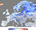
File:Europe Temperature Map 2009-12.png
Appearance
Europe_Temperature_Map_2009-12.png (481 × 415 pixels, file size: 304 KB, MIME type: image/png)
File history
Click on a date/time to view the file as it appeared at that time.
| Date/Time | Thumbnail | Dimensions | User | Comment | |
|---|---|---|---|---|---|
| current | 17:20, 12 January 2010 |  | 481 × 415 (304 KB) | Jolly Janner | Reverted to version as of 16:07, 12 January 2010 other one is better illustrated. Gets grainy at high res anyway. |
| 16:58, 12 January 2010 |  | 1,243 × 743 (402 KB) | Jolly Janner | higher resolution | |
| 16:07, 12 January 2010 |  | 481 × 415 (304 KB) | Currentlybiscuit | {{Information |Description={{en|1=Map of Europe showing the difference of temperature between December 11–18, 2009 and the 2000–2008 average.}} |Source=http://earthobservatory.nasa.gov/IOTD/view.php?id=42067 |Author=NASA |Date=2009-12-18 |Permission= |
File usage
The following page uses this file:
Global file usage
The following other wikis use this file:
- Usage on es.wikipedia.org
- Usage on fr.wikipedia.org
- Usage on no.wikipedia.org
- Usage on sv.wikipedia.org


