| DescriptionF5tornadoes.jpg |
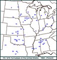
English: A map detailing all of the F5 and EF5 tornadoes in the United States since 1950. The numbers refer to their chronological order starting with the #1 event in 1953. Updated through June 9, 2013.
NUMBER DATE LOCATION
===================== =====================
- 59 - May 20, 2013 Moore, OK
- 58 - May 24, 2011 Piedmont, OK
- 57 - May 22, 2011 Joplin MO
- 56 - April 27, 2011 Rainsville/Sylvania Al
- 55 - April 27, 2011 Preston MS
- 54 - April 27, 2011 Hackleburg/Phil Campbell AL
- 53 - April 27, 2011 Smithville MS
- 52 - May 25, 2008 Parkersburg IA
- 51 - May 4, 2007 Greensburg KS
- 50 - May 3, 1999 Bridge Creek/Moore OK
- 49 - April 16, 1998 Waynesboro TN
- 48 - April 8, 1998 Pleasant Grove AL
- 47 - May 27, 1997 Jarrell TX
- 46 - July 18, 1996 Oakfield WI
- 45 - June 16, 1992 Chandler MN
- 44 - April 26, 1991 Andover KS
- 43 - August 28, 1990 Plainfield IL
- 42 - March 13, 1990 Goessel KS
- 41 - March 13, 1990 Hesston KS
- 40 - May 31, 1985 Niles OH
- 39 - June 7, 1984 Barneveld WI
- 38 - April 2, 1982 Broken Bow OK
- 37 - April 4, 1977 Birmingham AL
- 36 - June 13, 1976 Jordan IA
- 35 - April 19, 1976 Brownwood TX
- 34 - March 26, 1976 Spiro OK
- 33 - April 3, 1974 Guin AL
- 32 - April 3, 1974 Tanner AL
- 31 - April 3, 1974 Mt. Hope AL
- 30 - April 3, 1974 Sayler Park OH
- 29 - April 3, 1974 Brandenburg KY
- 28 - April 3, 1974 Xenia OH
- 27 - April 3, 1974 Daisy Hill IN
- 26 - May 6, 1973 Valley Mills TX
- 25 - February 21, 1971 Delhi LA
- 24 - May 11, 1970 Lubbock TX
- 23 - June 13, 1968 Tracy MN
- 22 - May 15, 1968 Maynard IA
- 21 - May 15, 1968 Charles City IA
- 20 - April 23, 1968 Gallipolis OH
- 19 - October 14, 1966 Belmond IA
- 18 - June 8, 1966 Topeka KS
- 17 - March 3, 1966 Jackson MS
- 16 - May 8, 1965 Gregory SD
- 15 - May 5, 1964 Bradshaw NE
- 14 - April 3, 1964 Wichita Falls TX
- 13 - May 5, 1960 Prague OK
- 12 - June 4, 1958 Menomonie WI
- 11 - December 18, 1957 Murphysboro IL
- 10 - June 20, 1957 Fargo ND
- 9 - May 20, 1957 Ruskin Heights MO
- 8 - April 3, 1956 Grand Rapids MI
- 7 - May 25, 1955 Udall KS
- 6 - May 25, 1955 Blackwell OK
- 5 - December 5, 1953 Vicksburg MS
- 4 - June 27, 1953 Adair IA
- 3 - June 8, 1953 Flint MI
- 2 - May 29, 1953 Ft. Rice ND
- 1 - May 11, 1953 Waco TX
|


