
File:FARBEN DWORY.png

Size of this preview: 681 × 600 pixels. Other resolutions: 273 × 240 pixels | 545 × 480 pixels | 872 × 768 pixels | 1,024 × 902 pixels.
Original file (1,024 × 902 pixels, file size: 681 KB, MIME type: image/png)
| This is a file from the Wikimedia Commons. Information from its description page there is shown below. Commons is a freely licensed media file repository. You can help. |
Summary
| Description |
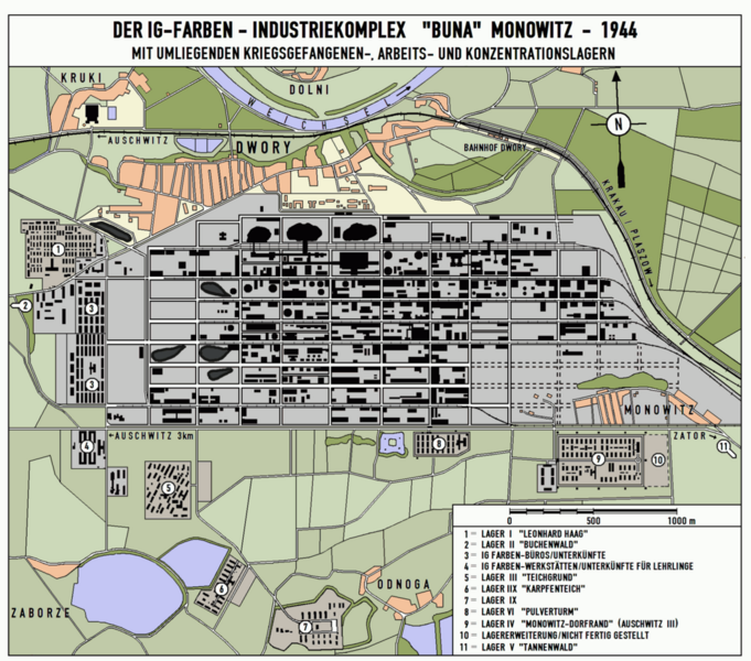
Deutsch: Die Karte zeigt den IG-FARBEN-Werkskomplex Monowitz/Dwory sowie die umliegenden Lager auf dem Stand von 1944.
English: I.G. Farbens Buna-Werke industrial complex near Dwory, Poland. Diagram shows Monowitz and various subcamps as of 1944. |
| Date | |
| Source |
Deutsch: Die Karte wurde von mir selbst angefertigt, basierend auf:
|
| Author | HEROMAX |
| Permission (Reusing this file) |
HEROMAX, the copyright holder of this work, hereby publishes it under the following license: This file is licensed under the Creative Commons Attribution-Share Alike 3.0 Unported license. Attribution: HEROMAX
|
Original upload log
The original description page was here. All following user names refer to de.wikipedia.
- 2006-03-11 14:45 HEROMAX (Die Karte zeigt den IG-FARBEN-Werkskomplex Monowitz/Dwory sowie die umliegenden Lager auf dem Stand von 1944. Die Karte wurde von mir selbst angefertigt. Quellen: Topographische Karte Oswiecim, vermutlich 1:25000 von etwa 1995; diverse Luftbilder der USAF)
| Annotations | This image is annotated: View the annotations at Commons |
File history
Click on a date/time to view the file as it appeared at that time.
| Date/Time | Thumbnail | Dimensions | User | Comment | |
|---|---|---|---|---|---|
| current | 16:37, 20 August 2015 | | 1,024 × 902 (681 KB) | Drdoht | {{Information |Description=Die Karte zeigt den IG-FARBEN-Werkskomplex Monowitz/Dwory sowie die umliegenden Lager auf dem Stand von 1944. |Source=Die Karte wurde von mir selbst angefertigt, basierend auf:<br /> Topographische Karte Oswiecim, vermutlich... |
File usage
The following pages on the English Wikipedia use this file (pages on other projects are not listed):
Global file usage
The following other wikis use this file:
- Usage on af.wikipedia.org
- Usage on cs.wikipedia.org
- Usage on de.wikipedia.org
- Usage on gl.wikipedia.org
- Usage on hu.wikipedia.org
- Usage on it.wikipedia.org
- Usage on nl.wikipedia.org
- Usage on pl.wikipedia.org
- Usage on ru.wikipedia.org
- Usage on uz.wikipedia.org