
File:Fuerstbistum Speyer 1753.jpg

Original file (4,723 × 4,024 pixels, file size: 9.97 MB, MIME type: image/jpeg)
| This is a file from the Wikimedia Commons. Information from its description page there is shown below. Commons is a freely licensed media file repository. You can help. |
Summary
| Description |
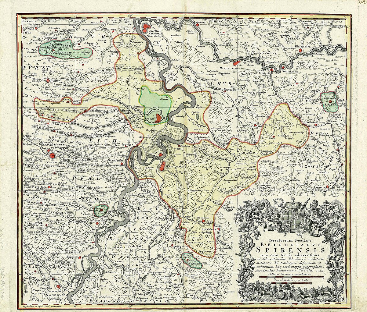
Deutsch: Karte des Fürstbistums Speyer (in gelb, plus vier Exklaven in aqua). Dies ist, wie der Titel der Karte besagt, das weltliche Territorium ("Territorium seculare") des Bischofs und nicht seine Diözese, die größer war. Die Karte zeigt auch das vom Bischof unabhängige Gebiet der Reichsstadt Speyer (hellgrün).
Die Karte wurde von Cyriak Blödner (1672-1733) gezeichnet, einem Militäroffizier, Ingenieur und Kartographen, der während des Spanischen Erbfolgekrieges (1701-1714) an der Planung der Rheinverteidigung beteiligt war. Diese Karte mit dem Titel „Territorium seculare Episcopatus Spirensis“ kam erst ans Licht, als Homanns Erben sie 1753 veröffentlichten. English: Map of the Prince-Bishopric of Speyer (in yellow, plus four exclaves in aqua). This is, as the title of the map indicates, the secular territory ("Territorium seculare") of the bishop, and not his diocese, which was larger. The map also shows the territory of the Imperial city of Speyer (in light green), which was independent of the bishop.
The map was drawn by Cyriak Blödner (1672-1733), a military officer, engineer and cartographer who had been involved in planning the defence of the Rhine during the War of the Spanish Succession (1701-1714). This map, titled Territorium seculare Episcopatus Spirensis, only came to light when Homann's Heirs (Homanns Erben) decided to publish it in 1753. Français : Carte de la principauté épiscopale de Spire (en jaune, plus quatre exclaves couleur aqua). On distingue également le territoire de la ville impériale de Spire (en vert), indépendante de l'évêque. La carte a été dessinée par Cyriak Blödner (1672-1733), officier, ingénieur et cartographe qui avait pris part à la planification de la défense du Rhin durant la Guerre de succession d'Espagne (1701-1714). Cette carte fut seulement publiée en 1753 par les Héritiers d'Homann (Homanns Erben). |
| Source | Cyriak Blödner - Homanns Erben 1753 |
| Author | Saarlandbilder.net 23:28, 6. Feb. 2008 (CET) |
Licensing
|
This work is in the public domain in its country of origin and other countries and areas where the copyright term is the author's life plus 70 years or fewer.
| |
| This file has been identified as being free of known restrictions under copyright law, including all related and neighboring rights. | |
Original upload log
Transferred from de.wikipedia to Commons by Ireas using CommonsHelper.
- 2008-02-06 22:28 Saarlandbilder.net 512×453× (100850 bytes) {{Information |Beschreibung = Karte des Fürstbistums Speyer |Quelle = Homann Heirs 1735 |Urheber = ~~~~ |Datum = |Genehmigung = |Andere Versionen = |Anmerkungen = }}
File history
Click on a date/time to view the file as it appeared at that time.
| Date/Time | Thumbnail | Dimensions | User | Comment | |
|---|---|---|---|---|---|
| current | 12:28, 14 August 2018 | | 4,723 × 4,024 (9.97 MB) | Lubiesque | Much larger map with better resolution |
| 16:20, 28 September 2010 |  | 512 × 453 (98 KB) | File Upload Bot (Magnus Manske) | {{BotMoveToCommons|de.wikipedia|year={{subst:CURRENTYEAR}}|month={{subst:CURRENTMONTHNAME}}|day={{subst:CURRENTDAY}}}} {{Information |Description={{de|Karte des Fürstbistums Speyer}} |Source=Transferred from [http://de.wikipedia.org de.wikipedia]; trans |
File usage
Global file usage
The following other wikis use this file:
- Usage on de.wikipedia.org
- Usage on eo.wikipedia.org
- Usage on es.wikipedia.org
- Usage on fr.wikipedia.org
- Usage on it.wikipedia.org
- Usage on nl.wikipedia.org
- Usage on pt.wikipedia.org
- Usage on ru.wikipedia.org