File:Fukuoka Quake 2005 Seismicity KegoDansou.png
Appearance
Fukuoka_Quake_2005_Seismicity_KegoDansou.png (246 × 246 pixels, file size: 11 KB, MIME type: image/png)
File history
Click on a date/time to view the file as it appeared at that time.
| Date/Time | Thumbnail | Dimensions | User | Comment | |
|---|---|---|---|---|---|
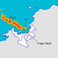
| current | 08:10, 6 May 2005 |  | 246 × 246 (11 KB) | Oarih~commonswiki | Map of Fukuoka City showing epicentre of March 20th quake and rough map of subsequent seismic activity along with location of the Kego fault. Made using data from [http://www.sevo.kyushu-u.ac.jp/HYPO/index.html] and maps from Japanese Wikipedia with the |
| 06:33, 3 May 2005 |  | 246 × 246 (11 KB) | Oarih~commonswiki | Map of Fukuoka City showing epicentre of March 20th quake and rough map of subsequent seismic activity along with location of the Kego fault. Made using data from [http://www.sevo.kyushu-u.ac.jp/HYPO/index.html] and maps from Japanese Wikipedia with the | |
| 06:32, 3 May 2005 |  | 246 × 246 (3 KB) | Oarih~commonswiki | Map of Fukuoka City showing epicentre of March 20th quake and rough map of subsequent seismic activity along with location of the Kego fault. Made using data from [http://www.sevo.kyushu-u.ac.jp/HYPO/index.html] and maps from Japanese Wikipedia with the |
File usage
The following page uses this file:
Global file usage
The following other wikis use this file:
- Usage on fr.wikipedia.org
- Usage on ja.wikipedia.org
- Usage on ja.wikinews.org
- Usage on tr.wikipedia.org

