
File:Geomap Rhoen.jpg
Size of this preview: 576 × 599 pixels. Other resolutions: 231 × 240 pixels | 461 × 480 pixels | 738 × 768 pixels | 984 × 1,024 pixels | 1,969 × 2,048 pixels | 3,549 × 3,692 pixels.
Original file (3,549 × 3,692 pixels, file size: 2.69 MB, MIME type: image/jpeg)
| This is a file from the Wikimedia Commons. Information from its description page there is shown below. Commons is a freely licensed media file repository. You can help. |
Summary
| Description |
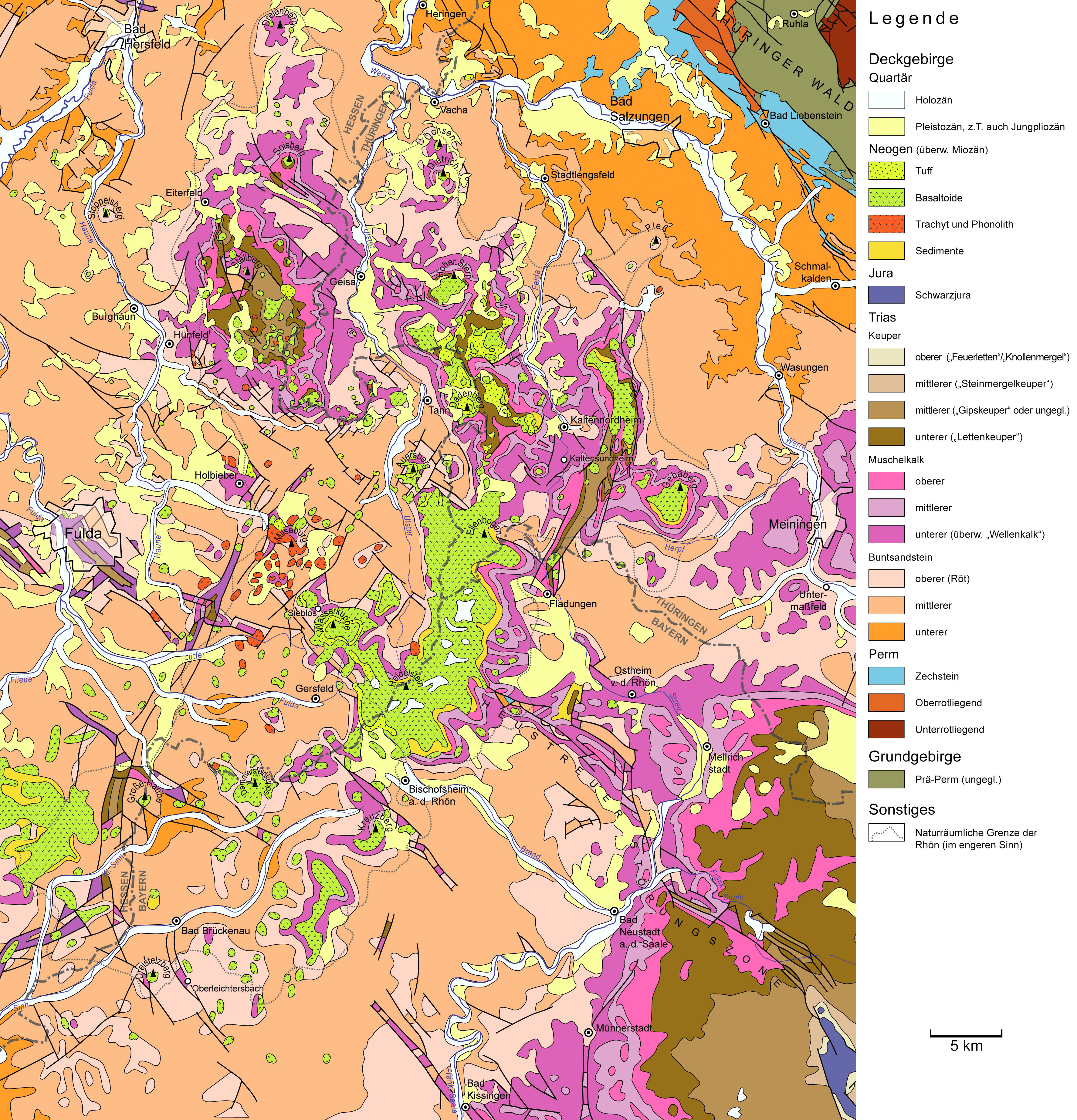
English: Geological map of the Rhoen Mountains, a volcanic mountain range in Central Germany. Data source: official geological maps of Hesse, Thuringia, and Bavaria.
Deutsch: Geologische Karte der Rhön. Quellen: GÜK 300 Hessen, GÜK 200 Thüringen, GÜK 500 Bayern. |
||
| Date | |||
| Source | Own work | ||
| Author | Gretarsson | ||
| Other versions |
|


Licensing
I, the copyright holder of this work, hereby publish it under the following licenses:

|
Permission is granted to copy, distribute and/or modify this document under the terms of the GNU Free Documentation License, Version 1.2 or any later version published by the Free Software Foundation; with no Invariant Sections, no Front-Cover Texts, and no Back-Cover Texts. A copy of the license is included in the section entitled GNU Free Documentation License. |
This file is licensed under the Creative Commons Attribution-Share Alike 3.0 Unported, 2.5 Generic, 2.0 Generic and 1.0 Generic license.
- You are free:
- to share – to copy, distribute and transmit the work
- to remix – to adapt the work
- Under the following conditions:
- attribution – You must give appropriate credit, provide a link to the license, and indicate if changes were made. You may do so in any reasonable manner, but not in any way that suggests the licensor endorses you or your use.
- share alike – If you remix, transform, or build upon the material, you must distribute your contributions under the same or compatible license as the original.
You may select the license of your choice.
File history
Click on a date/time to view the file as it appeared at that time.
| Date/Time | Thumbnail | Dimensions | User | Comment | |
|---|---|---|---|---|---|
| current | 20:35, 24 March 2021 | | 3,549 × 3,692 (2.69 MB) | Gretarsson | last version was accidentally saved in CMYK color space causing rendering errors |
| 19:43, 24 March 2021 |  | 3,549 × 3,692 (4.35 MB) | Gretarsson | missing town label “Bad Liebenstein” added; label “Basalt” in legend replaced by “Basaltoid” since this is more accurate (SiO2-poor volcanic rocks in Rhön Mts are not only basalts in a stric sense but includes also basanite and nephelinite) | |
| 14:56, 14 June 2013 |  | 3,549 × 3,692 (4.53 MB) | Gretarsson | Border of physical geographic unit "Rhoen Mts. sensu stricto" altered + some minor edits (e.g. typos) | |
| 14:56, 13 June 2013 |  | 3,549 × 3,692 (4.53 MB) | Gretarsson | Map extended northward and eastward. Missing features in old map (1 town, a few faults) added. | |
| 10:32, 29 May 2013 |  | 3,194 × 3,437 (2.54 MB) | Gretarsson | {{Information |Description ={{en|1=Geological map of the Rhoen Mountains, a volcanic mountain range in Central Germany. Data source: official geological maps of Hesse, Thuringia, and Bavaria.}} {{de|1=Geologische Karte der Rhön. Quellen: GÜK 300 H... |
File usage
The following pages on the English Wikipedia use this file (pages on other projects are not listed):
Global file usage
The following other wikis use this file:
- Usage on de.wikipedia.org