
File:Geomap Thur-Franc-Vogtl-SM.png

Size of this preview: 800 × 541 pixels. Other resolutions: 320 × 216 pixels | 640 × 433 pixels | 1,024 × 692 pixels | 1,280 × 866 pixels | 2,560 × 1,731 pixels | 3,261 × 2,205 pixels.
Original file (3,261 × 2,205 pixels, file size: 2.49 MB, MIME type: image/png)
| This is a file from the Wikimedia Commons. Information from its description page there is shown below. Commons is a freely licensed media file repository. You can help. |
Summary
| Description |
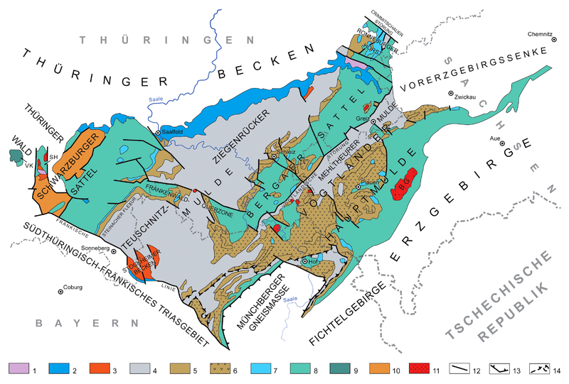
English: Geologic overview map of the Thuringian-Franconian-Vogtlandian Slate Mountains (without Quaternary). Meaning of numbers in the legend: 1-3 = undeformed post-Variscan cover, 4-10 = rocks deformed by Variscan orogeny, 11 intrusive rocks, 12-14 tectonic features. 1 = Triassic, 2 = Upper Permian (Zechstein), 3 = Uppermost Carboniferous and Lower Permian (Rotliegend), 4 = Lower Carboniferous (Mississippian), 5 = Devonian sedimentary rocks, 6 = Devonian basalts and spilites, 7 = Silurian, 8 = Ordovician, 9 = Cambrian, 10 = Precambrian, 11 = variscan granitoid bodies, 12 = main faults, 13 = margin of metamorphic rocks of the Münchberg Massif (probably part of a nappe), 14 = margin of "bavarian facies" of the non-metamorphic paleozoic succession (probably a nappe but uncertain). Abbreviations:, BG = Bergen Granite, SH = "Schleuse-Horst" (a horst structure named after the Schleuse River), VK = "Vesser Komplex" (volcanosedimentary rock association of Vesser). After Henningsen & Katzung (2006), Linnemann (2003), and several geologic maps of Germany (GÜK 200).
Deutsch: Geologische Übersichtskarte des Thüringisch-Fränkisch-Vogtländischen Schiefergebirges (ohne Quartär). Bedeutung der Zahlen in der Legende: 1-3 = undeformierte post-variszische Überdeckung, 4-10 = Variszisch deformierte Gesteine, 11 = magmatische Intrusivgesteine, 12-14 = strukturgeologische Elemente. 1 = Trias, 2 = Oberperm (Zechstein), 3 = oberstes Karbon und Unterperm (Rotliegend), 4 = Unterkarbon, 5 = devonische Sedimentgesteine, 6 = devonische Diabase und Spilite, 7 = Silur, 8 = Ordovizium, 9 = Kambrium, 10 = Präkambrium, 11 = variszische granitoide Gesteinskörper, 12 = Hauptstörungen, 13 = Rand der Münchberger Gneismasse (wahrscheinlich Teil einer Überschiebungsdecke), 14 = Grenze der "Bayerischen Fazies" der paläozoischen Abfolge (möglicherweise Teil einer Überschiebungsdecke). Abkürzungen: BG = Bergener Granit, SH = Schleuse-Horst, VK = Vesser Komplex. Nach Henningsen & Katzung (2006), Linnemann (2003) und verschiedenen GÜK 200. |
| Date | |
| Source | Own work |
| Author | Gretarsson |
| Other versions |
 |
References
- Linnemann, Ulf: Die Struktureinheiten des Saxothuringikums. Geologica Saxonica 48/49, 2003, pp. 19-28
- Henningsen, Dierk & Katzung, Gerhard: Einführung in die Geologie Deutschlands. 7. Auflage, Spektrum Akademischer Verlag, München 2006, 234 p. ISBN 978-3-8274-1586-1 Invalid ISBN
Licensing
I, the copyright holder of this work, hereby publish it under the following licenses:

|
Permission is granted to copy, distribute and/or modify this document under the terms of the GNU Free Documentation License, Version 1.2 or any later version published by the Free Software Foundation; with no Invariant Sections, no Front-Cover Texts, and no Back-Cover Texts. A copy of the license is included in the section entitled GNU Free Documentation License. |
This file is licensed under the Creative Commons Attribution-Share Alike 3.0 Unported, 2.5 Generic, 2.0 Generic and 1.0 Generic license.
- You are free:
- to share – to copy, distribute and transmit the work
- to remix – to adapt the work
- Under the following conditions:
- attribution – You must give appropriate credit, provide a link to the license, and indicate if changes were made. You may do so in any reasonable manner, but not in any way that suggests the licensor endorses you or your use.
- share alike – If you remix, transform, or build upon the material, you must distribute your contributions under the same or compatible license as the original.
You may select the license of your choice.
File history
Click on a date/time to view the file as it appeared at that time.
| Date/Time | Thumbnail | Dimensions | User | Comment | |
|---|---|---|---|---|---|
| current | 13:04, 5 March 2013 | | 3,261 × 2,205 (2.49 MB) | Gretarsson | Labelling: RQZ replaced by Ronneburg Horst, Crimmitschau Fault added |
| 16:50, 4 January 2013 |  | 3,261 × 2,140 (2.46 MB) | Gretarsson | Geology of Ronneburg area and some labels added; legend: ordering altered | |
| 02:20, 10 October 2012 |  | 3,261 × 1,968 (2.32 MB) | Gretarsson | Parts of outcrop of Schwarzburg anticline re-assigned to Ordovician. Devonian volcanites designated. | |
| 13:35, 27 September 2012 |  | 3,261 × 1,968 (2.18 MB) | Gretarsson | New features and labels added (Steinach Flexure, Stockheim Basin) | |
| 17:28, 13 September 2012 |  | 3,261 × 1,968 (2.23 MB) | Gretarsson | White background added | |
| 17:23, 13 September 2012 |  | 3,261 × 1,968 (2.38 MB) | Gretarsson | {{Information |Description ={{en|1=Geologic overview map of the Thuringian-Franconian-Vogtlandian Slate Mountains (without Quaternary). Meaning of numbers in the legend: 1-6 = rocks deformed by Variscan orogeny, 7-9 undeformed post-Variscan cover, 1... |
File usage
The following pages on the English Wikipedia use this file (pages on other projects are not listed):
Global file usage
The following other wikis use this file:
- Usage on de.wikipedia.org
- Usage on de.wikibooks.org
- Usage on www.wikidata.org