
File:Helsinki metro plan 1963.png
Size of this preview: 800 × 566 pixels. Other resolutions: 320 × 226 pixels | 640 × 453 pixels | 1,024 × 724 pixels | 1,280 × 905 pixels | 2,560 × 1,810 pixels | 4,961 × 3,508 pixels.
Original file (4,961 × 3,508 pixels, file size: 4.54 MB, MIME type: image/png)
| This is a file from the Wikimedia Commons. Information from its description page there is shown below. Commons is a freely licensed media file repository. You can help. |
Summary
| Description |
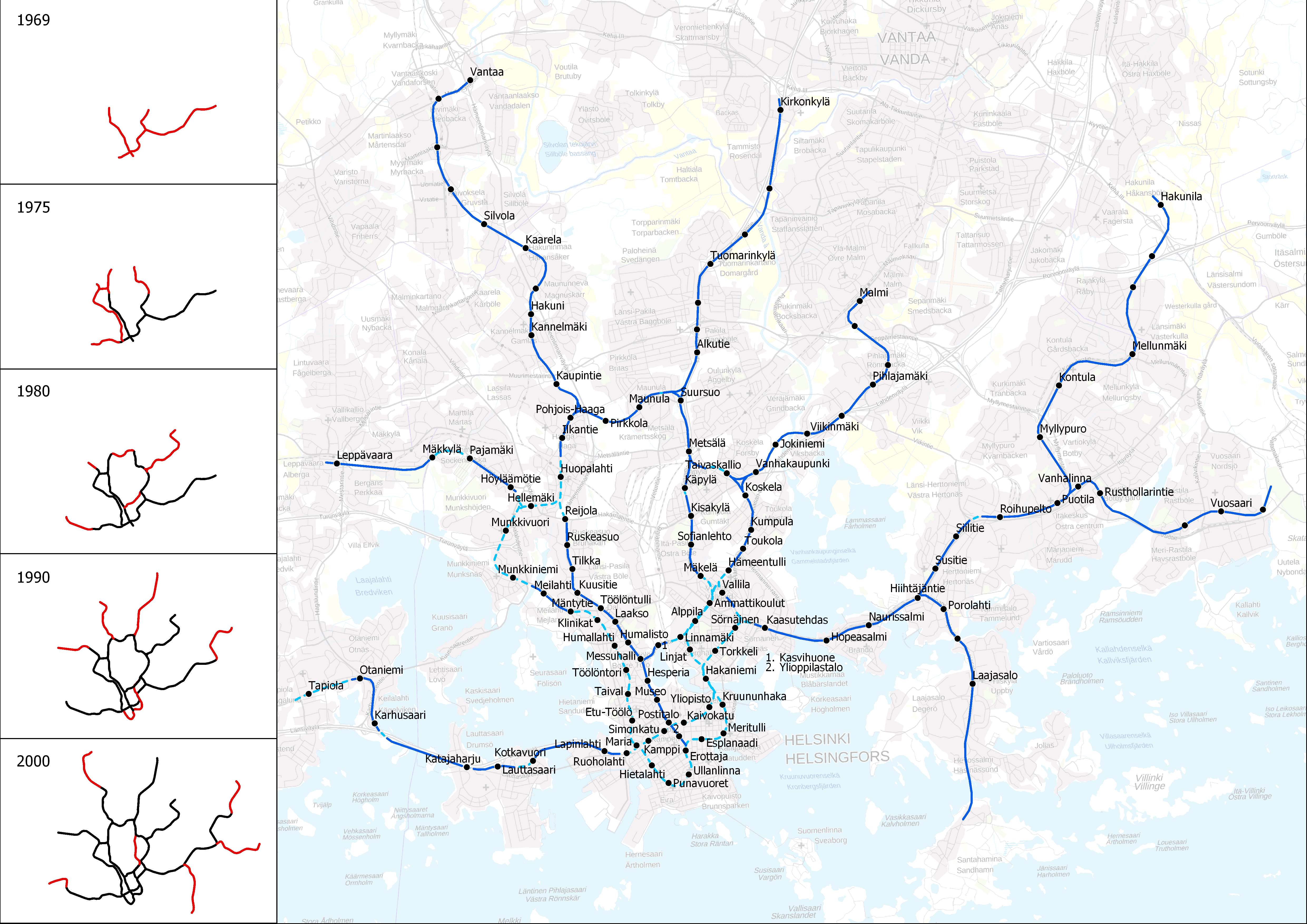
English: The Metro Commission's 1963 proposal for a metro system in Helsinki. Dark blue = above ground tracks, dashed light blue = underground tracks. Left: proposed construction stages. Basemap from 2018.
Suomi: Metrotoimikunnan vuoden 1963 ehdotus Helsingin metrojärjestelmäksi. Tummansininen = maanpäällinen rata, vaaleansininen katkoviiva = maanalainen rata. Vasemmalla: ehdotetut rakentamisvaiheet. Pohjakartta vuodelta 2018.
Svenska: Metrokommissionens förslag till ett metrosystem för Helsingfors 1963. Mörkblå = bana på markytan, ljusblå = bana i tunnel. Till vänster: föreslagna utbyggnadsskeden. Baskarta från 2018. |
| Date | |
| Source | Own work based on various maps and diagrams in "Helsingin kaupungin metrotoimikunnan mietintö, osa II" (1963). Basemap by Maanmittauslaitos (CC BY 4.0) |
| Author | Migro |
Licensing
I, the copyright holder of this work, hereby publish it under the following license:
This file is licensed under the Creative Commons Attribution-Share Alike 4.0 International license.
- You are free:
- to share – to copy, distribute and transmit the work
- to remix – to adapt the work
- Under the following conditions:
- attribution – You must give appropriate credit, provide a link to the license, and indicate if changes were made. You may do so in any reasonable manner, but not in any way that suggests the licensor endorses you or your use.
- share alike – If you remix, transform, or build upon the material, you must distribute your contributions under the same or compatible license as the original.
File history
Click on a date/time to view the file as it appeared at that time.
| Date/Time | Thumbnail | Dimensions | User | Comment | |
|---|---|---|---|---|---|
| current | 13:08, 11 March 2018 | | 4,961 × 3,508 (4.54 MB) | Migro | User created page with UploadWizard |
File usage
The following page uses this file:
Global file usage
The following other wikis use this file:
- Usage on da.wikipedia.org
- Usage on es.wikipedia.org
- Usage on fi.wikipedia.org
- Usage on sv.wikipedia.org