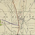
File:Historical map series for the area of Wadi al-Hawarith (1940s).jpg
Appearance

Size of this preview: 596 × 599 pixels. Other resolutions: 239 × 240 pixels | 477 × 480 pixels | 743 × 747 pixels.
Original file (743 × 747 pixels, file size: 119 KB, MIME type: image/jpeg)
File history
Click on a date/time to view the file as it appeared at that time.
| Date/Time | Thumbnail | Dimensions | User | Comment | |
|---|---|---|---|---|---|
| current | 10:15, 27 September 2020 |  | 743 × 747 (119 KB) | Crash48 | Wrong coordinates were used; the new coordinates clearly show "El Hawarith" label |
| 21:45, 24 July 2020 |  | 743 × 747 (319 KB) | Onceinawhile | Uploaded with ComeOn! 3.5.1 |
File usage
The following page uses this file:


