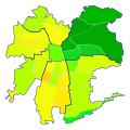
File:IDH Santiago.svg
Appearance

Size of this PNG preview of this SVG file: 600 × 600 pixels. Other resolutions: 240 × 240 pixels | 480 × 480 pixels | 768 × 768 pixels | 1,024 × 1,024 pixels | 2,048 × 2,048 pixels.
Original file (SVG file, nominally 600 × 600 pixels, file size: 61 KB)
File history
Click on a date/time to view the file as it appeared at that time.
| Date/Time | Thumbnail | Dimensions | User | Comment | |
|---|---|---|---|---|---|
| current | 02:56, 20 August 2007 |  | 600 × 600 (61 KB) | B1mbo | {{Information |Description={{es|Mapa de las comunas de Santiago de Chile según su Índice de Desarrollo Humano (2006). Además, se agrupan por sectores geográficos (Centro, Nororiente, Suroriente, Sur, Surponiente, Norponiente, Norte). {{legend|#00A |
File usage
No pages on the English Wikipedia use this file (pages on other projects are not listed).
