
File:Jung-gu incheon location.svg

Size of this PNG preview of this SVG file: 482 × 475 pixels. Other resolutions: 244 × 240 pixels | 487 × 480 pixels | 779 × 768 pixels | 1,039 × 1,024 pixels | 2,078 × 2,048 pixels.
Original file (SVG file, nominally 482 × 475 pixels, file size: 538 KB)
| This is a file from the Wikimedia Commons. Information from its description page there is shown below. Commons is a freely licensed media file repository. You can help. |
Summary
| Description |
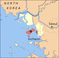
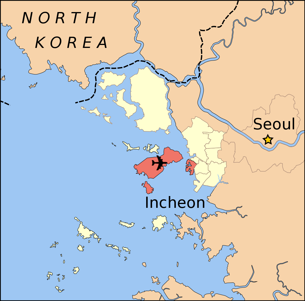
English: Location of Jung-gu (including islands) within Incheon Metropolitan City, South Korea |
| Date | |
| Source | Own work |
| Author | Amble |
| SVG development |
| Camera location | | View this and other nearby images on: OpenStreetMap |
|---|
Created using NASA Landsat data from zulu.ssc.nasa.gov archive copy at the Wayback Machine
DMZ location from Demis World Map Server archive copy at the Wayback Machine
With reference to maps from Incheon City Government for administrative divisions
Licensing
I, the copyright holder of this work, hereby publish it under the following licenses:
This file is licensed under the Creative Commons Attribution-Share Alike 3.0 Unported license.
- You are free:
- to share – to copy, distribute and transmit the work
- to remix – to adapt the work
- Under the following conditions:
- attribution – You must give appropriate credit, provide a link to the license, and indicate if changes were made. You may do so in any reasonable manner, but not in any way that suggests the licensor endorses you or your use.
- share alike – If you remix, transform, or build upon the material, you must distribute your contributions under the same or compatible license as the original.

|
Permission is granted to copy, distribute and/or modify this document under the terms of the GNU Free Documentation License, Version 1.2 or any later version published by the Free Software Foundation; with no Invariant Sections, no Front-Cover Texts, and no Back-Cover Texts. A copy of the license is included in the section entitled GNU Free Documentation License. |
You may select the license of your choice.
File history
Click on a date/time to view the file as it appeared at that time.
| Date/Time | Thumbnail | Dimensions | User | Comment | |
|---|---|---|---|---|---|
| current | 06:03, 31 July 2008 | | 482 × 475 (538 KB) | Amble | {{Information |Description={{en|1=Location of Jung-gu (including islands) within Incheon Metropolitan City, South Korea}} |Source=Own work by uploader |Author=Amble |Date=July 30, 2008 |Permission= |other_versions= }} Created using NASA Lan |
File usage
No pages on the English Wikipedia use this file (pages on other projects are not listed).
Global file usage
The following other wikis use this file:
- Usage on it.wikipedia.org
- Usage on ja.wikipedia.org
- Usage on sco.wikipedia.org
- Usage on sv.wikipedia.org