
File:Karel-IV..jpg
Size of this preview: 798 × 599 pixels. Other resolutions: 320 × 240 pixels | 639 × 480 pixels | 912 × 685 pixels.
Original file (912 × 685 pixels, file size: 385 KB, MIME type: image/jpeg)
| This is a file from the Wikimedia Commons. Information from its description page there is shown below. Commons is a freely licensed media file repository. You can help. |

|
This historical map image could be re-created using vector graphics as an SVG file. This has several advantages; see Commons:Media for cleanup for more information. If an SVG form of this image is available, please upload it and afterwards replace this template with
{{vector version available|new image name}}.
It is recommended to name the SVG file “Karel-IV..svg”—then the template Vector version available (or Vva) does not need the new image name parameter. |


Summary
| Description |
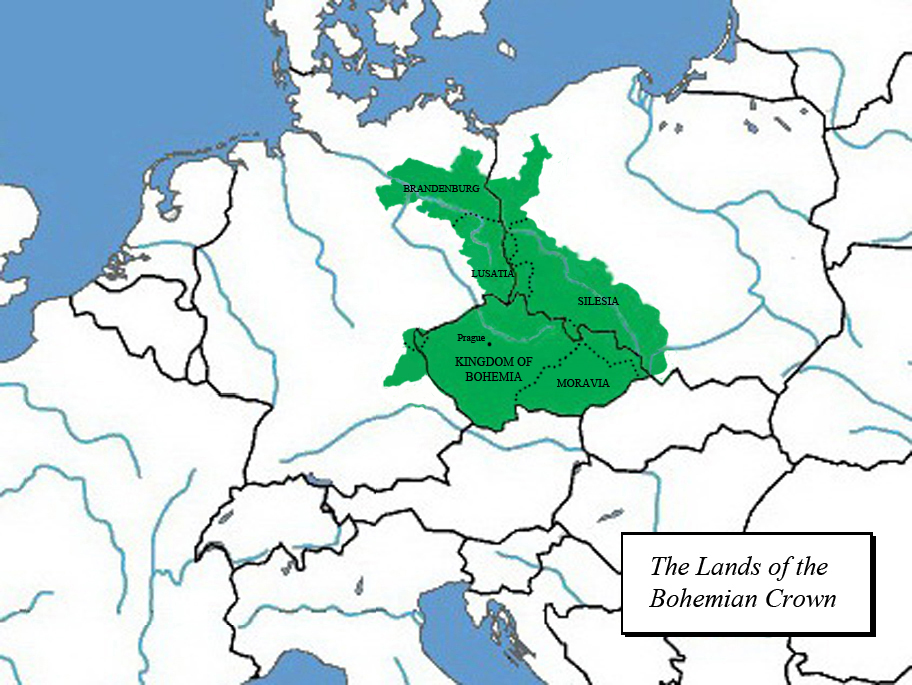
Čeština: maximální rozsah zemí Koruny české za Karla IV.
English: Czech lands during the reign of Charles IV. |
| Date | |
| Source | Own work |
| Author | Jirka.h23 |
Licensing
I, the copyright holder of this work, hereby publish it under the following license:
This file is licensed under the Creative Commons Attribution-Share Alike 3.0 Unported license.
- You are free:
- to share – to copy, distribute and transmit the work
- to remix – to adapt the work
- Under the following conditions:
- attribution – You must give appropriate credit, provide a link to the license, and indicate if changes were made. You may do so in any reasonable manner, but not in any way that suggests the licensor endorses you or your use.
- share alike – If you remix, transform, or build upon the material, you must distribute your contributions under the same or compatible license as the original.
File history
Click on a date/time to view the file as it appeared at that time.
| Date/Time | Thumbnail | Dimensions | User | Comment | |
|---|---|---|---|---|---|
| current | 11:33, 11 February 2013 | | 912 × 685 (385 KB) | Jirka.h23 | boundary lines of the provinces |
| 15:16, 2 January 2013 |  | 912 × 685 (367 KB) | Jirka.h23 | specified based on historical maps (mainly in Brandenburg and in Upper palatinate), improved image size resolution. | |
| 12:31, 3 August 2012 |  | 422 × 317 (74 KB) | Jirka.h23 | zoom | |
| 12:18, 3 August 2012 |  | 878 × 659 (254 KB) | Jirka.h23 |
File usage
No pages on the English Wikipedia use this file (pages on other projects are not listed).
Global file usage
The following other wikis use this file:
- Usage on de.wikipedia.org