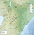
File:Kenya topographic map-fr.svg
Appearance

Size of this PNG preview of this SVG file: 575 × 599 pixels. Other resolutions: 230 × 240 pixels | 460 × 480 pixels | 737 × 768 pixels | 982 × 1,024 pixels | 1,965 × 2,048 pixels | 1,181 × 1,231 pixels.
Original file (SVG file, nominally 1,181 × 1,231 pixels, file size: 3.26 MB)
File history
Click on a date/time to view the file as it appeared at that time.
| Date/Time | Thumbnail | Dimensions | User | Comment | |
|---|---|---|---|---|---|
| current | 19:48, 14 August 2023 |  | 1,181 × 1,231 (3.26 MB) | Sémhur | Correction des latitudes et longitudes |
| 10:00, 30 April 2008 |  | 1,181 × 1,231 (3.28 MB) | Sémhur | Orthograph : provence => province | |
| 19:48, 7 April 2008 |  | 1,181 × 1,231 (3.28 MB) | Pinpin | == Description == {{Information |Description={{fr|Carte topographique du Kenya. Version française}} {{en|Topographic map in French of Kenya}} |Source=Own Work made with Inkscape From <br/>Topographic map : [http://www2.jpl.nasa.gov/srtm NASA Shuttle Rada |
File usage
The following page uses this file:
Global file usage
The following other wikis use this file:
- Usage on avk.wikipedia.org
- Usage on ca.wikipedia.org
- Usage on de.wikipedia.org
- Usage on es.wikipedia.org
- Usage on fr.wikipedia.org
- Usage on nl.wikipedia.org
- Usage on ps.wikipedia.org
- Usage on ru.wikipedia.org
- Usage on uk.wikipedia.org

