
File:Libia regiones.PNG
No higher resolution available.
Libia_regiones.PNG (181 × 144 pixels, file size: 7 KB, MIME type: image/png)
| This is a file from the Wikimedia Commons. Information from its description page there is shown below. Commons is a freely licensed media file repository. You can help. |
Summary
Deutsch: Historische Provinzen (Governorates) Libyens
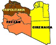
English: Map of the three Governorates of Libya. After independence in 1951, until 1963, Libya was divided into three governorates (muhafazat): Cyrenaica, Tripolitania, and Fezzan.
Español: Mapa de las tres governorates de Libia: Tripolitania, Fezzan, y Cirenaica.
Français : Carte de les trois governorates de Libya.

|
This file has been superseded by Historische Provinzen Libyens.png. It is recommended to use the other file. Please note that deleting superseded images requires consent. Reason to use the other file: "Higher resolution"
|

|
Licensing
| I, the copyright holder of this work, release this work into the public domain. This applies worldwide. In some countries this may not be legally possible; if so: I grant anyone the right to use this work for any purpose, without any conditions, unless such conditions are required by law. |
File history
Click on a date/time to view the file as it appeared at that time.
| Date/Time | Thumbnail | Dimensions | User | Comment | |
|---|---|---|---|---|---|
| current | 22:39, 5 September 2006 | | 181 × 144 (7 KB) | Antgb~commonswiki | Mapa de las tres regiones de Libia: Tripolitania, Fezzan y Cirenaica Map of the three regions of Lybia Category:Maps |
File usage
No pages on the English Wikipedia use this file (pages on other projects are not listed).
Global file usage
The following other wikis use this file:
- Usage on ar.wikipedia.org
- Usage on br.wikipedia.org
- Usage on fi.wikipedia.org
- Usage on fr.wikipedia.org
- Usage on he.wikipedia.org
- Usage on hu.wikipedia.org
- Usage on ja.wikipedia.org
- Usage on pl.wikipedia.org
- Usage on ro.wikipedia.org
- Usage on sv.wikipedia.org
- Usage on zh.wikipedia.org