File:Location of Bougainville.jpg
Appearance
Location_of_Bougainville.jpg (223 × 251 pixels, file size: 56 KB, MIME type: image/jpeg)
File history
Click on a date/time to view the file as it appeared at that time.
| Date/Time | Thumbnail | Dimensions | User | Comment | |
|---|---|---|---|---|---|
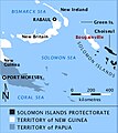
| current | 11:12, 24 March 2010 |  | 223 × 251 (56 KB) | SpoolWhippets | {{Information |Description={{en|1=Map showing location of Bougainville relative to New Guinea, New Britain and New Ireland, also indicating political division of Territories c. 1942. Green Islands and Choiseul I. are indicated, also towns of Rabaul and Po |
File usage
The following 5 pages use this file:
Global file usage
The following other wikis use this file:
- Usage on azb.wikipedia.org
- Usage on de.wikipedia.org
- Usage on it.wikipedia.org
- Usage on www.wikidata.org
- Usage on zh.wikipedia.org

