
File:Locationtemplepkhan.png
No higher resolution available.
Locationtemplepkhan.png (249 × 206 pixels, file size: 13 KB, MIME type: image/png)
| This is a file from the Wikimedia Commons. Information from its description page there is shown below. Commons is a freely licensed media file repository. You can help. |
Summary

|
This locator map image could be re-created using vector graphics as an SVG file. This has several advantages; see Commons:Media for cleanup for more information. If an SVG form of this image is available, please upload it and afterwards replace this template with
{{vector version available|new image name}}.
It is recommended to name the SVG file “Locationtemplepkhan.svg”—then the template Vector version available (or Vva) does not need the new image name parameter. |
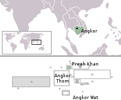
| Description |
English: Location of temple Preah Khan |
| Source |
This file was derived from: |
| Author |
Licensing
| I, the copyright holder of this work, release this work into the public domain. This applies worldwide. In some countries this may not be legally possible; if so: I grant anyone the right to use this work for any purpose, without any conditions, unless such conditions are required by law. |
File history
Click on a date/time to view the file as it appeared at that time.
| Date/Time | Thumbnail | Dimensions | User | Comment | |
|---|---|---|---|---|---|
| current | 04:12, 25 August 2005 | | 249 × 206 (13 KB) | Markalexander100 | {{PD}} Modified from http://de.wikipedia.org/wiki/Bild:Angkor_Satellit_mit_Karte.jpg and [Image:LocationAngkor.png] |
File usage
The following pages on the English Wikipedia use this file (pages on other projects are not listed):
Global file usage
The following other wikis use this file:
- Usage on es.wikipedia.org
- Usage on hr.wikipedia.org
- Usage on hu.wikipedia.org
- Usage on it.wikipedia.org
- Usage on pt.wikipedia.org