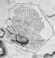
File:Louis François Sébastien Fauvel-athens-before1800.jpg
Appearance
Louis_François_Sébastien_Fauvel-athens-before1800.jpg (563 × 586 pixels, file size: 280 KB, MIME type: image/jpeg)
File history
Click on a date/time to view the file as it appeared at that time.
| Date/Time | Thumbnail | Dimensions | User | Comment | |
|---|---|---|---|---|---|
| current | 10:45, 17 August 2010 |  | 563 × 586 (280 KB) | ChristosV | {{Information |Description={{en|1=Map of the city of Athens, made before 1800 }} |Source=map |Author=Louis François_Sébastien Fauvel |Date=before 1800 |Permission= |other_versions= }} Category:Athens |
File usage
The following 3 pages use this file:
Global file usage
The following other wikis use this file:
- Usage on ar.wikipedia.org
- Usage on de.wikipedia.org
- Usage on el.wikipedia.org
- Usage on es.wikipedia.org
- Usage on fr.wikipedia.org
- Usage on gl.wikipedia.org
- Usage on hyw.wikipedia.org
- Usage on it.wikipedia.org
- Usage on la.wikipedia.org
- Usage on oc.wikipedia.org
- Usage on ru.wikipedia.org
- Usage on ur.wikipedia.org
- Usage on www.wikidata.org

