
File:Luxembourg administrative subdivisions coloured.gif
Size of this preview: 444 × 599 pixels. Other resolutions: 178 × 240 pixels | 600 × 809 pixels.
Original file (600 × 809 pixels, file size: 30 KB, MIME type: image/gif)
| This is a file from the Wikimedia Commons. Information from its description page there is shown below. Commons is a freely licensed media file repository. You can help. |
Summary
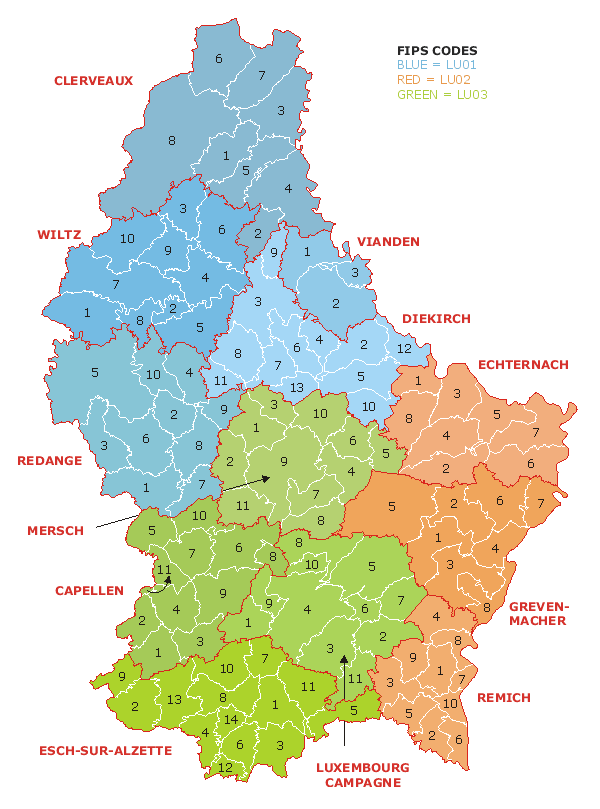
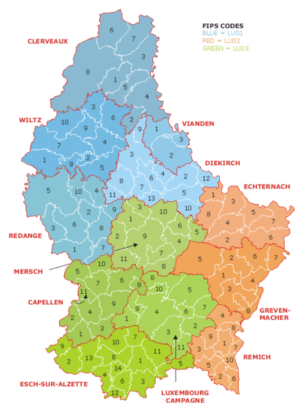
| Description | Map of the administrative divisions of Luxembourg. Districts, cantons, and communes are marked and numbered according to FIPS code. |
| Date | |
| Source | Own work based on w:Image:Luxembourg.geohive.gif, which previously had all rights released by its original author and publisher, GeoHive. Updated for the commune mergers of 2006-01-01. |
| Author | User:Bastin8 |
| Permission (Reusing this file) |
Released into public domain. See licence below. |

|
File:Luxembourg administrative subdivisions coloured.svg is a vector version of this file. It should be used in place of this GIF file when not inferior.
File:Luxembourg administrative subdivisions coloured.gif → File:Luxembourg administrative subdivisions coloured.svg
For more information, see Help:SVG. |
 |
Licensing
| I, the copyright holder of this work, release this work into the public domain. This applies worldwide. In some countries this may not be legally possible; if so: I grant anyone the right to use this work for any purpose, without any conditions, unless such conditions are required by law. |
File history
Click on a date/time to view the file as it appeared at that time.
| Date/Time | Thumbnail | Dimensions | User | Comment | |
|---|---|---|---|---|---|
| current | 20:08, 27 August 2024 | | 600 × 809 (30 KB) | GiAnMMV | Corrected "Clerveaux" with "Clervaux". |
| 00:19, 21 July 2006 |  | 600 × 809 (30 KB) | Bastin8 | {{Information |Description=Map of the administrative divisions of Luxembourg. Districts, cantons, and communes are marked and numbered according to FIPS code. |Source=Own work based on w:Image:Luxembourg.geohive.gif, which previously had all rights r |
File usage
No pages on the English Wikipedia use this file (pages on other projects are not listed).
Global file usage
The following other wikis use this file:
- Usage on an.wikipedia.org
- Usage on ast.wikipedia.org
- Usage on es.wikipedia.org
- Usage on eu.wikipedia.org
- Usage on fur.wikipedia.org
- Usage on gag.wikipedia.org
- Usage on id.wikipedia.org
- Usage on it.wikipedia.org
- Usage on kk.wikipedia.org
- Usage on ko.wikipedia.org
- Usage on lt.wikipedia.org
- Usage on mk.wikipedia.org
- Usage on nl.wikipedia.org
- Usage on pt.wikipedia.org
- Usage on ro.wikipedia.org
- Usage on ru.wikipedia.org
- Usage on sco.wikipedia.org
- Usage on sq.wikipedia.org
- Usage on tr.wikipedia.org
- Usage on uz.wikipedia.org
- Usage on zh.wikipedia.org