
File:Map Greece expansion 1832-1947-zhcn.svg

Size of this PNG preview of this SVG file: 457 × 599 pixels. Other resolutions: 183 × 240 pixels | 366 × 480 pixels | 586 × 768 pixels | 781 × 1,024 pixels | 1,562 × 2,048 pixels | 734 × 962 pixels.
Original file (SVG file, nominally 734 × 962 pixels, file size: 109 KB)
| This is a file from the Wikimedia Commons. Information from its description page there is shown below. Commons is a freely licensed media file repository. You can help. |
| Description |
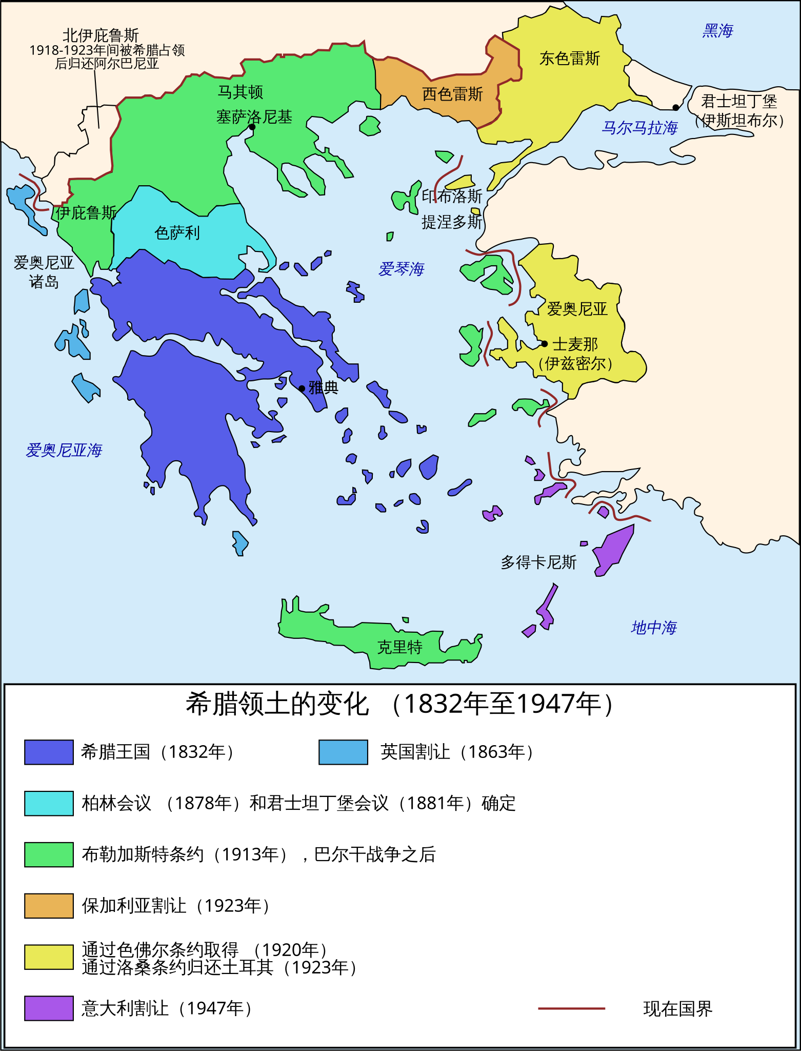
Čeština: Mapa zobrazuje územní expanzi Řeckého království (1832–1947). Dansk: Kort over Grækenlands territoriale udvidelser, 1832-1947. Deutsch: Territoriale Expansion Griechenlands 1832-1947. English: The territorial expansion of Greece, 1832-1947. Español: Mapa de la expansión territorial griega (1832-1947) Euskara: Greziaren lurralde hedapena 1832-1947 bitartean Français : L'expansion territoriale de la Grèce. 1832-1947. Hrvatski: Teritorijalno proširenje Grčke u razdoblju od 1832. do 1947. Italiano: L'espansione territoriale della Grecia dal 1832 al 1947 Magyar: Görögország területi növekedése (1832-1947) Occitan : Evolucions territòrialas de Grècia. Ελληνικά: Η εδαφική επέκταση της Ελλάδας 1832-1947. Македонски: Територијално проширување на Грција Українська: Територіальна експансія Греції (1832-1947). 日本語: ギリシャ王国の版図拡大 (1832-1947年) 中文: 希腊的领土变迁,1832年-1947年间。 العربية : خريطة تُصوِّر الأراضي التي استولت عليها اليونان مُنذُ سنة 1832م حين استقلالها عن الدولة العُثمانيَّة، وُصولًا إلى سنة 1947م |
||
| Date | (UTC) | ||
| Source | |||
| Author |
|
||
| Other versions |
[]
|


.PNG)


.png)


| This is a retouched picture, which means that it has been digitally altered from its original version. Modifications: Translated into simplified Chinese. The original can be viewed here: Map Greece expansion 1832-1947-en.svg:
|
I, the copyright holder of this work, hereby publish it under the following licenses:
| This file is licensed under the Creative Commons Attribution-Share Alike 3.0 Unported license. | ||
| ||
| This licensing tag was added to this file as part of the GFDL licensing update. |

|
Permission is granted to copy, distribute and/or modify this document under the terms of the GNU Free Documentation License, Version 1.2 or any later version published by the Free Software Foundation; with no Invariant Sections, no Front-Cover Texts, and no Back-Cover Texts. A copy of the license is included in the section entitled GNU Free Documentation License. |
You may select the license of your choice.
Original upload log
This image is a derivative work of the following images:
- File:Map_Greece_expansion_1832-1947-en.svg licensed with Cc-by-sa-3.0-migrated, GFDL
- 2008-12-05T14:46:53Z Future Perfect at Sunrise 734x962 (121736 Bytes) marked present border
- 2008-12-05T12:31:19Z Future Perfect at Sunrise 734x962 (112647 Bytes) corrected "Western Thrace"; tweaked some captions
- 2007-03-31T11:10:35Z Rursus 734x962 (112342 Bytes)
Uploaded with derivativeFX
File history
Click on a date/time to view the file as it appeared at that time.
| Date/Time | Thumbnail | Dimensions | User | Comment | |
|---|---|---|---|---|---|
| current | 12:44, 24 February 2011 | | 734 × 962 (109 KB) | Extvia | {{Information |Description={{en|The territorial expansion of Greece, 1832-1947.}} {{zh|希腊的领土变迁,1832年-1947年间。}} |Source=*File:Map_Greece_expansion_1832-1947-en.svg |Date=2011-02-24 12:42 (UTC) |Author=*[[:File:Map_Greece_expan |
File usage
No pages on the English Wikipedia use this file (pages on other projects are not listed).
Global file usage
The following other wikis use this file:
- Usage on wuu.wikipedia.org
- Usage on zh.wikipedia.org