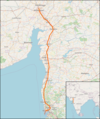
File:Map high-speed line Mumbai–Ahmedabad.png
Appearance

Size of this preview: 502 × 599 pixels. Other resolutions: 201 × 240 pixels | 402 × 480 pixels | 765 × 913 pixels.
Original file (765 × 913 pixels, file size: 750 KB, MIME type: image/png)
File history
Click on a date/time to view the file as it appeared at that time.
| Date/Time | Thumbnail | Dimensions | User | Comment | |
|---|---|---|---|---|---|
| current | 11:36, 24 May 2021 |  | 765 × 913 (750 KB) | Pechristener | {{Information |description={{de|1=Schnellfahrstrecke Mumbai–Ahmedabad}}{{en|1=Loaction map of Indian high-speed line Mumbai–Ahmedabad. Status May 2021}} |date=2021-05-24 |source=Screen shot of OSM |author=Pechristener |permission=Map data (c) OpenStreetMap (and) contributors, CC-BY-SA |other versions= }} =={{int:license-header}}== {{cc-by-sa-2.0}} Category:High speed railway lines in Asia Category:Rail transport maps of India [[Category:OpenStreetMap maps of Ind... |
File usage
The following 2 pages use this file:
Global file usage
The following other wikis use this file:
- Usage on de.wikipedia.org
- Usage on hu.wikipedia.org
- Usage on nl.wikipedia.org
- Usage on www.wikidata.org
