
File:Map indicating Victoria Island, northern Canada.png
No higher resolution available.
Map_indicating_Victoria_Island,_northern_Canada.png (428 × 380 pixels, file size: 67 KB, MIME type: image/png)
| This is a file from the Wikimedia Commons. Information from its description page there is shown below. Commons is a freely licensed media file repository. You can help. |
Summary
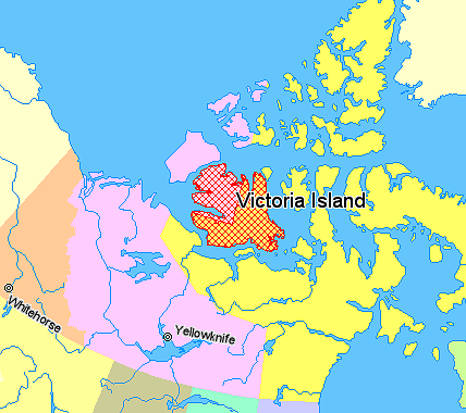
Map indicating Victoria Island, northern Canada.
Nunavut
Northwest Territories
Yukon Territory
British Columbia
Regions outside Canada (Alaska, Greenland)
© Her Majesty the Queen in Right of Canada, Department of Natural Resources. All rights reserved.
Licence Agreement
Licensing

|
The copyright holder of this work allows anyone to use it for any purpose including unrestricted redistribution, commercial use, and modification.
Usage notes:
|
File history
Click on a date/time to view the file as it appeared at that time.
| Date/Time | Thumbnail | Dimensions | User | Comment | |
|---|---|---|---|---|---|
| current | 01:19, 21 March 2006 | | 428 × 380 (67 KB) | David Kernow~commonswiki | Map indicating Victoria Island, northern Canada. {{legend|#ffff66|Nunavut}} {{legend|#ffccff|Northwest Territories}} {{legend|#ffcc99|Yukon Territory}} {{legend|#ffff99|British Columbia}} {{legend|#ffffcc|Regions outside Canada (Ala |
File usage
No pages on the English Wikipedia use this file (pages on other projects are not listed).
Global file usage
The following other wikis use this file:
- Usage on es.wikipedia.org
- Usage on eu.wikipedia.org
- Usage on fr.wikipedia.org
- Usage on gl.wikipedia.org
- Usage on it.wikipedia.org
- Usage on pt.wikipedia.org
- Usage on ro.wikipedia.org